IMAGES TAKEN NEAR TO
Hodge Clough Road, OLDHAM, OL1 4PW
Introduction
This page details the photographs taken nearby to Hodge Clough Road, OL1 4PW by members of the Geograph project.
The Geograph project started in 2005 with the aim of publishing, organising and preserving representative images for every square kilometre of Great Britain, Ireland and the Isle of Man.

There are currently over 7.5m images from over14,400 individuals and you can help contribute to the project by visiting https://www.geograph.org.uk
Image Map
Images are licensed for reuse under creativecommons.org/licenses/by-sa/2.0
Notes
- Clicking on the map will re-center to the selected point.
- The higher the marker number, the further away the image location is from the centre of the postcode.
Image Listing (8 Images Found)
Images are licensed for reuse under creativecommons.org/licenses/by-sa/2.0
Image
Details
Distance
1
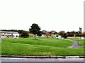
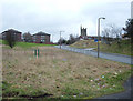
Sholver Green
The original Sholver estate was a concrete jungle of flats and maisonettes, and acquired a reputation as a no-go area. Most of the old estate was demolished and now has been rebuilt with modern housing and better, more open aspects.
Image: © Roger May
Taken: 10 Oct 2005
0.08 miles
3
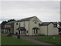
The Northgate, Sholver
This is the main estate pub situated on Sholver Green.
Image: © michael ely
Taken: 25 Feb 2007
0.15 miles
4
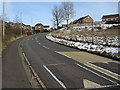
Cop Road Sholver
Approaching the steepest section of the road as it climbs out of the Beal Valley. The houses are the start of Bottom Sholver where the road is marked by a chevron on the OS 1/50,000 map.
Image: © michael ely
Taken: 22 Feb 2010
0.17 miles
5
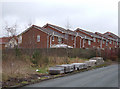
Bottom Sholver
Looking northeast up Cop Road at the western end of Sholver's refurbished housing estate. At the time this photo was taken Cop Road was closed for repairs.
Image: © michael ely
Taken: 25 Feb 2007
0.17 miles
6
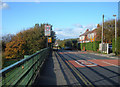
Sholver Lane
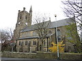
Sholver Lane is the road seen right of shot as it climbs from Sholver Green to its junction with the A672, Ripponden Road. Sholver parish church can be seen in the distance.
Image: © michael ely
Taken: 25 Feb 2007
0.20 miles
7
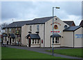
Wilkes Street, Sholver
Looking north towards the centre of Sholver from the junction with Ripponden Road (A672). There are extensive views west, over the railings at left of shot, of the Beal Valley and a major landfill site.
Image: © michael ely
Taken: 17 Oct 2007
0.22 miles