IMAGES TAKEN NEAR TO
Cheltenham Street, OLDHAM, OL1 4DA
Introduction
This page details the photographs taken nearby to Cheltenham Street, OL1 4DA by members of the Geograph project.
The Geograph project started in 2005 with the aim of publishing, organising and preserving representative images for every square kilometre of Great Britain, Ireland and the Isle of Man.

There are currently over 7.5m images from over14,400 individuals and you can help contribute to the project by visiting https://www.geograph.org.uk
Image Map
Images are licensed for reuse under creativecommons.org/licenses/by-sa/2.0
Notes
- Clicking on the map will re-center to the selected point.
- The higher the marker number, the further away the image location is from the centre of the postcode.
Image Listing (26 Images Found)
Images are licensed for reuse under creativecommons.org/licenses/by-sa/2.0
Image
Details
Distance
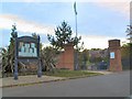
1
Block of historic houses, Albert Mount
Block of houses with internal courtyard, dated to 1862, viewed from Bartlemore Street, Derker.
Image: © Kevin Waterhouse
Taken: 26 Feb 2023
0.04 miles
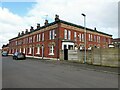
2
Old Coop
Taken during a heritage walk in Derker
Image: © Stephen Darlington
Taken: 9 Sep 2015
0.07 miles
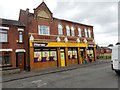
3
Stoneleigh Park
Local notices on the board outside the entrance to Stoneleigh Park, on Buxted Road, Derker.
Image: © Roger May
Taken: 10 Oct 2005
0.10 miles
4
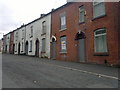
Acre Lane, Oldham
Terraced houses on Acre Lane, in the Derker area of Oldham, Greater Manchester, England.
Located northeast of Oldham town centre, Derker is composed of a mixture of industrial, semi-industrial and residential properties. Its housing stock - mostly Victorian and Edwardian era red-brick terraces - was identified by the Housing Market Renewal scheme as unsuitable for human habitation in around the year 2000, and was earmarked for a vast demolition and gentrification project, particularly as Derker railway station was to become a Metrolink station. The late-2000s financial crisis brought the scheme to an end and properties like those on Acre Lane have sadly remained boarded-up, derelict and abandoned.
Image: © Steven Haslington
Taken: 25 Jul 2011
0.11 miles
5
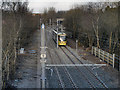
Tram Approaching Derker Station
Metrolink Bombardier tram number 3012 approaches Derker Station from Shaw on the day that the Oldham line was extended from Mumps to Shaw and Crompton.
Image: © David Dixon
Taken: 16 Dec 2012
0.15 miles
6
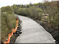
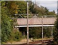
Former Oldham Loop Line
The track from the former Oldham loop (railway) line, which closed in October 2009, has been taken up and the bed is being relaid ready for the new Metrolink tramway which is due to open in 2012.
This view is looking north from the bridge at Acre Lane, Higginshaw.
Image: © David Dixon
Taken: 6 Apr 2011
0.15 miles
7
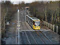
Metrolink Tram Approaching Derker
Metrolink Bombardier tram 3012 approaches the Derker Station from Shaw on the day that the Oldham line was extended from Mumps to Shaw and Crompton.
Image: © David Dixon
Taken: 16 Dec 2012
0.15 miles
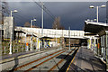
8
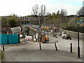
Metrolink Work at Derker Station
Work being undertaken to the Yates Street Bridge, over the site of the former Derker Railway Station (see Image]).
Derker railway station was a station on the Oldham Loop Line, and was managed by Northern Rail at the time of closure in 2009. It was originally opened on 30 August 1985 to replace Royton Junction station, ½ mile further along the line.
The station closed on 3 October 2009 for the conversion of the line to Metrolink and will re-open as Derker Metrolink station in 2012.
Image: © David Dixon
Taken: 6 Apr 2011
0.16 miles
9
Footbridge over the tramway
Carrying a footpath from Acre to a local school.
Image: © philandju
Taken: 18 Sep 2017
0.16 miles
10
Darker at Derker
This is the first Metrolink station from Oldham centre heading towards Rochdale.
Image: © Alan Murray-Rust
Taken: 7 Jan 2014
0.17 miles