IMAGES TAKEN NEAR TO
Jumble Hole Road, TODMORDEN, OL14 8SU
Introduction
This page details the photographs taken nearby to Jumble Hole Road, OL14 8SU by members of the Geograph project.
The Geograph project started in 2005 with the aim of publishing, organising and preserving representative images for every square kilometre of Great Britain, Ireland and the Isle of Man.

There are currently over 7.5m images from over14,400 individuals and you can help contribute to the project by visiting https://www.geograph.org.uk
Image Map
Images are licensed for reuse under creativecommons.org/licenses/by-sa/2.0
Notes
- Clicking on the map will re-center to the selected point.
- The higher the marker number, the further away the image location is from the centre of the postcode.
Image Listing (31 Images Found)
Images are licensed for reuse under creativecommons.org/licenses/by-sa/2.0
Image
Details
Distance
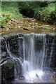
1
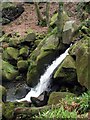
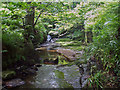
Jumble Hole Clough
Waterfall in Cowbridge Wood, on the fast flowing stream tumbling down the steep valley to the River Calder.
Image: © Paul Glazzard
Taken: 28 Mar 2007
0.08 miles
2
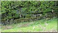
Beverley End
Historic site of terraced tenter grounds and weaver's cottage
Image: © Kevin Waterhouse
Taken: 9 May 2021
0.09 miles
3
Jumble Hole Clough
Fast flowing stream tumbling down the steep valley to the River Calder, looking northwest from the footbridge between Dean Wood and Beverley Wood.
Image: © Paul Glazzard
Taken: 28 Mar 2007
0.09 miles
4
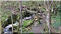
Beverley Footbridge
In Jumble Hole Clough
Image: © Kevin Waterhouse
Taken: 9 May 2021
0.10 miles
5
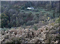
View from the Pennine Bridleway
Looking into Jumble Hole Clough from a hairpin bend on the descent from Blackshaw Head.
Image: © michael ely
Taken: 1 Nov 2008
0.10 miles
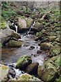
6
Attractive waterfall in Jumble hole clough.
Image: © steven ruffles
Taken: 1 Aug 2020
0.11 miles
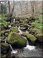
7
Staups Mill and waterfall, Jumble Hole Clough
Looking North from the Calderdale Way. This is one of several mills in Jumble Hole Clough which leads from the Hebden Bridge to Todmorden Road at the bottom of the clough and rises to a high point towards Blackshaw Head.
Image: © Mark Anderson
Taken: 26 Sep 2004
0.11 miles
8
Jumble Hole Clough
The fast flowing stream tumbling down the steep valley, just northwest of the footbridge between Dean Wood and Beverley Wood.
Image: © Paul Glazzard
Taken: 28 Mar 2007
0.11 miles
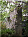
9
In the depths of Jumble Hole Clough
At one time the beck tumbling down Jumble Hole Clough powered several mills, now it passes picturesque ruins deep in the woods.
Image: © Phil Champion
Taken: 23 Jun 2002
0.14 miles
10
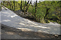
Hairpin bend on Pennine Bridleway, Jumble Hole Clough
This section of the Pennine Bridleway runs over a private access road used by vehicles. Recently concrete wheel tracks have been laid along this section
Image: © Phil Champion
Taken: 29 Apr 2007
0.14 miles