IMAGES TAKEN NEAR TO
Shore Green, TODMORDEN, OL14 8SF
Introduction
This page details the photographs taken nearby to Shore Green, OL14 8SF by members of the Geograph project.
The Geograph project started in 2005 with the aim of publishing, organising and preserving representative images for every square kilometre of Great Britain, Ireland and the Isle of Man.

There are currently over 7.5m images from over14,400 individuals and you can help contribute to the project by visiting https://www.geograph.org.uk
Image Map
Images are licensed for reuse under creativecommons.org/licenses/by-sa/2.0
Notes
- Clicking on the map will re-center to the selected point.
- The higher the marker number, the further away the image location is from the centre of the postcode.
Image Listing (16 Images Found)
Images are licensed for reuse under creativecommons.org/licenses/by-sa/2.0
Image
Details
Distance
1
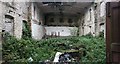
Shore Baptist Chapel interior
This is the dilapidated interior of Shore Baptist Chapel near Lydgate, Todmorden, West Yorkshire.
Image: © NigglePics
Taken: 22 Sep 2020
0.07 miles
2
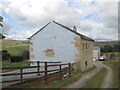
Shore General Baptist Chapel
Built in 1777 but now disused and in disrepair.
Image: © Bill Boaden
Taken: 24 Dec 2011
0.07 miles
3
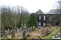
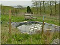
Outdoor baptismal area
This is the outdoor baptismal area for Shore Baptist Chapel above Cornholme. When the chapel first opened baptisms took place in the stream in the clough below the chapel. This baptismal area was then used before a baptismal area was built within the chapel itself.
Image: © Catherine Chatham
Taken: 1 May 2021
0.11 miles
4
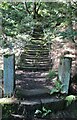
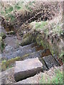
Stairway to Heaven
Steps out of Wittonstall Clough to Shore General Baptist Chapel
Image: © Kevin Waterhouse
Taken: 9 Sep 2020
0.11 miles
5
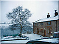
Higher Green End Farm
Looking west from Gall Lane north of Shore. Coal Clough windfarm can be seen on the skyline right of shot.
Image: © michael ely
Taken: 14 Mar 2008
0.13 miles
6
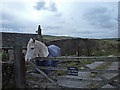
Ducks at Blue Bell farm
These white ducks may be kept for meat or eggs.
Image: © Stephen Craven
Taken: 2 May 2022
0.14 miles
7

Gorse on the hillside above Cornholme
Bushes on a steep slope alongside Wittonstall Clough.
Image: © Stephen Craven
Taken: 2 May 2022
0.15 miles
8

Path junction in Wittonstall Clough
Only the path going up to the right, which leads to Blue Bell Farm, is marked on the map as a public footpath.
Image: © Stephen Craven
Taken: 2 May 2022
0.16 miles
9
Mount Pleasant Farm
View towards Brown Birks.
Image: © Mount Pleasant
Taken: 25 Dec 2004
0.17 miles