IMAGES TAKEN NEAR TO
Woodbine Terrace, TODMORDEN, OL14 8NL
Introduction
This page details the photographs taken nearby to Woodbine Terrace, OL14 8NL by members of the Geograph project.
The Geograph project started in 2005 with the aim of publishing, organising and preserving representative images for every square kilometre of Great Britain, Ireland and the Isle of Man.

There are currently over 7.5m images from over14,400 individuals and you can help contribute to the project by visiting https://www.geograph.org.uk
Image Map
Images are licensed for reuse under creativecommons.org/licenses/by-sa/2.0
Notes
- Clicking on the map will re-center to the selected point.
- The higher the marker number, the further away the image location is from the centre of the postcode.
Image Listing (115 Images Found)
Images are licensed for reuse under creativecommons.org/licenses/by-sa/2.0
Image
Details
Distance

4

Todmorden FP66 in Dawk Hole Wood, Pudsey
Image: © Humphrey Bolton
Taken: 21 Feb 2019
0.04 miles
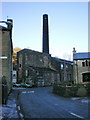
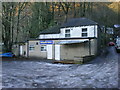
8
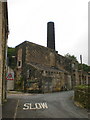
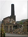
Soon to be no more the mill on Pudsey Road
Now in the process of being demolished. The link photo only shows part has been demolished. http://www.geograph.org.uk/photo/1077238
Image: © Alexander P Kapp
Taken: 10 Aug 2009
0.05 miles
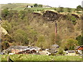
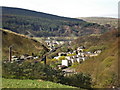
10

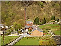
View of Pudsey, Todmorden
This was taken from a little rocky knoll at the top of the steep footpath up through Dawk Hole Wood.
Image: © Humphrey Bolton
Taken: 21 Feb 2019
0.05 miles