IMAGES TAKEN NEAR TO
John Barker Street, TODMORDEN, OL14 8HF
Introduction
This page details the photographs taken nearby to John Barker Street, OL14 8HF by members of the Geograph project.
The Geograph project started in 2005 with the aim of publishing, organising and preserving representative images for every square kilometre of Great Britain, Ireland and the Isle of Man.

There are currently over 7.5m images from over14,400 individuals and you can help contribute to the project by visiting https://www.geograph.org.uk
Image Map
Images are licensed for reuse under creativecommons.org/licenses/by-sa/2.0
Notes
- Clicking on the map will re-center to the selected point.
- The higher the marker number, the further away the image location is from the centre of the postcode.
Image Listing (90 Images Found)
Images are licensed for reuse under creativecommons.org/licenses/by-sa/2.0
Image
Details
Distance
2
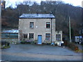
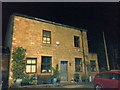
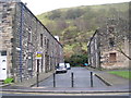
Former Poultry Dealers Arms.
Now a private house
Image: © Alexander P Kapp
Taken: 8 Dec 2008
0.01 miles
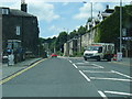
3
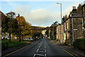
Burnley Road, Lydgate
Section of A646 between Burnley and Halifax
Image: © Chris Heaton
Taken: 25 Oct 2022
0.01 miles
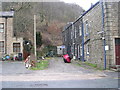
5
The Poultry Dealers Arms (now a private house)
This building was once a pub called 'The Poultry Dealers Arms' it is now a private house, it was known locally as 'The Poults'.
Image: © NigglePics
Taken: 27 Apr 2014
0.01 miles
6
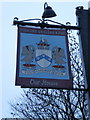
Poultry Dealers Arms, Sign
The pub is closed and now a house, with the sign being the only thing left to say that a pub was there.
Image: © Alexander P Kapp
Taken: 8 Dec 2008
0.02 miles
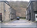
10
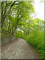
Jumps Lane, Todmorden
Like many such lanes that climb the hillsides in the upper Calder valley, this is unsurfaced and classed as a bridleway, not a public road.
Image: © Humphrey Bolton
Taken: 13 May 2010
0.03 miles