IMAGES TAKEN NEAR TO
Cross Lee Road, TODMORDEN, OL14 8EG
Introduction
This page details the photographs taken nearby to Cross Lee Road, OL14 8EG by members of the Geograph project.
The Geograph project started in 2005 with the aim of publishing, organising and preserving representative images for every square kilometre of Great Britain, Ireland and the Isle of Man.

There are currently over 7.5m images from over14,400 individuals and you can help contribute to the project by visiting https://www.geograph.org.uk
Image Map
Images are licensed for reuse under creativecommons.org/licenses/by-sa/2.0
Notes
- Clicking on the map will re-center to the selected point.
- The higher the marker number, the further away the image location is from the centre of the postcode.
Image Listing (40 Images Found)
Images are licensed for reuse under creativecommons.org/licenses/by-sa/2.0
Image
Details
Distance
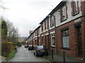
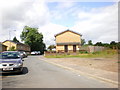
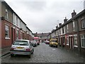
1
Junction of Dineley Avenue with Cross Lee Road
Image: © Alexander P Kapp
Taken: 8 Jul 2009
0.02 miles
2
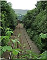
Railway to Cross Lee Road Bridge
View from Harley Wood footbridge
Image: © Kevin Waterhouse
Taken: 25 Jul 2021
0.05 miles
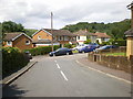
3
Looking towards Burnley
From Cross Lee Road
Image: © Alexander P Kapp
Taken: 8 Jul 2009
0.06 miles
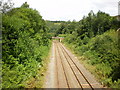
4
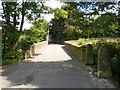
Cross Lee Road
As it crosses the Todmorden to Burnley Railway
Image: © Alexander P Kapp
Taken: 8 Jul 2009
0.06 miles
6
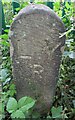
Railway Boundary Stone
A Lancashire & Yorkshire Railway boundary stone near path to Harley Wood railway footbridge
Image: © Kevin Waterhouse
Taken: 25 Jul 2021
0.11 miles
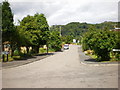
9
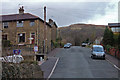
Cross Lee Road, Todmorden
Whirlaw Stones on the skyline.
Image: © michael ely
Taken: 14 Mar 2008
0.15 miles