IMAGES TAKEN NEAR TO
Ashenhurst Road, TODMORDEN, OL14 8DS
Introduction
This page details the photographs taken nearby to Ashenhurst Road, OL14 8DS by members of the Geograph project.
The Geograph project started in 2005 with the aim of publishing, organising and preserving representative images for every square kilometre of Great Britain, Ireland and the Isle of Man.

There are currently over 7.5m images from over14,400 individuals and you can help contribute to the project by visiting https://www.geograph.org.uk
Image Map
Images are licensed for reuse under creativecommons.org/licenses/by-sa/2.0
Notes
- Clicking on the map will re-center to the selected point.
- The higher the marker number, the further away the image location is from the centre of the postcode.
Image Listing (31 Images Found)
Images are licensed for reuse under creativecommons.org/licenses/by-sa/2.0
Image
Details
Distance
2
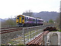
DMU 158843 travels towards Burnley through Todmorden
Image: © Robert Wade
Taken: 13 Apr 2009
0.16 miles
4
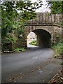
Bridge FHR6/5, Holme at Todmorden
Railway bridge over Ashenhurst Road.
Image: © David Dixon
Taken: 15 Sep 2020
0.17 miles
5
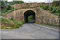
Railway Bridge over Ashenhurst Road
Bridge FHR6/5, Holme at Todmorden.
Image: © David Dixon
Taken: 15 Sep 2020
0.18 miles
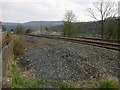
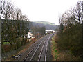
7
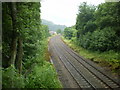
Todmorden to Burnley Railway
Looking west from Fernley Lee Bridge
Image: © Alexander P Kapp
Taken: 3 Jul 2009
0.19 miles
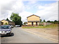
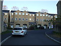
10
Mons Mill (Detail)
New housing is being built on the site of the now demolished Mons Mill.
Image: © Robert Wade
Taken: 25 Aug 2008
0.21 miles