IMAGES TAKEN NEAR TO
Reddyshore, Scout Gate Road, TODMORDEN, OL14 7TU
Introduction
This page details the photographs taken nearby to Reddyshore, Scout Gate Road, OL14 7TU by members of the Geograph project.
The Geograph project started in 2005 with the aim of publishing, organising and preserving representative images for every square kilometre of Great Britain, Ireland and the Isle of Man.

There are currently over 7.5m images from over14,400 individuals and you can help contribute to the project by visiting https://www.geograph.org.uk
Image Map
Images are licensed for reuse under creativecommons.org/licenses/by-sa/2.0
Notes
- Clicking on the map will re-center to the selected point.
- The higher the marker number, the further away the image location is from the centre of the postcode.
Image Listing (25 Images Found)
Images are licensed for reuse under creativecommons.org/licenses/by-sa/2.0
Image
Details
Distance
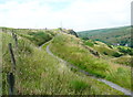
1
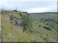
The Pennine Bridleway Mary Towneley loop near Reddyshore
Image: © Dave Kelly
Taken: 5 Jul 2019
0.12 miles
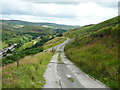
2
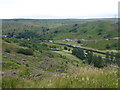
View from the Pennine Bridleway Mary Towneley loop near Reddyshore
Image: © Dave Kelly
Taken: 5 Jul 2019
0.13 miles
3
The Pennine Bridleway Mary Towneley loop near Reddyshore
Image: © Dave Kelly
Taken: 5 Jul 2019
0.14 miles
4
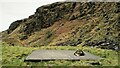
Summit Railway Tunnel Air Shaft No.9 Capped
Shaft below Reddyshore Scout
Image: © Kevin Waterhouse
Taken: 21 Apr 2021
0.15 miles
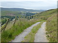
5
The Pennine Bridleway and Reddyshaw Scout, Walsden
A 'scout' is the top of a very steep hillside, giving a view over the valley. The lumpy hills below might be spoil from the construction of the railway tunnel.
Image: © Humphrey Bolton
Taken: 31 Jul 2017
0.15 miles
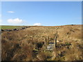
7
The Pennine Bridleway joining the driveway to Reddyshore Farm, Walsden
The bridleway on Reddyshaw Scout Gate comes in from the left, and from the junction the driveway is an adopted highway, at least as far as the Rochdale boundary.
Image: © Humphrey Bolton
Taken: 31 Jul 2017
0.16 miles
8
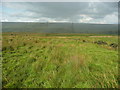
Not quite on the Rochdale Way, Walsden
After passing the Ferny Hill rocks I lost the footpath, so headed for the intake wall and picked my way through the rushes. The shower of rain has finished here and is crossing the valley in the distance.
Image: © Humphrey Bolton
Taken: 31 Jul 2017
0.17 miles
9
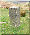
Allescholes Milestone
The other side of Image showing the distances by packhorse roads to Burnley as 9 miles and Todmorden as 2 miles.
This side of the stone has suffered more weathering.
Image: © John Illingworth
Taken: 15 Apr 2009
0.17 miles
10
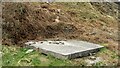
Summit Railway Tunnel Air Shaft No.8 Capped
Capped Shaft under Reddyshore Scout
Image: © Kevin Waterhouse
Taken: 21 Apr 2021
0.18 miles