IMAGES TAKEN NEAR TO
Watty Lane, TODMORDEN, OL14 7JQ
Introduction
This page details the photographs taken nearby to Watty Lane, OL14 7JQ by members of the Geograph project.
The Geograph project started in 2005 with the aim of publishing, organising and preserving representative images for every square kilometre of Great Britain, Ireland and the Isle of Man.

There are currently over 7.5m images from over14,400 individuals and you can help contribute to the project by visiting https://www.geograph.org.uk
Image Map
Images are licensed for reuse under creativecommons.org/licenses/by-sa/2.0
Notes
- Clicking on the map will re-center to the selected point.
- The higher the marker number, the further away the image location is from the centre of the postcode.
Image Listing (152 Images Found)
Images are licensed for reuse under creativecommons.org/licenses/by-sa/2.0
Image
Details
Distance
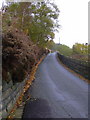
1

Watty Lane and TV / phone mast
This is shown as a television mast on large scale maps but I can find no reference in online databases of transmitters of anything at this location. Ofcom's Sitefinder records mobile phone base stations for all the main operators at this position.
Image: © Phil Champion
Taken: 19 Jun 2008
0.08 miles
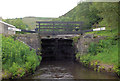
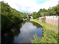
2
Gauxholme Lowest Lock 22 from above
Rochdale Canal
Image: © Mike Todd
Taken: 15 Jun 2011
0.11 miles
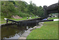
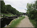
3
Gauxholme Lowest Lock 22 from below
Rochdale Canal
Image: © Mike Todd
Taken: 15 Jun 2011
0.11 miles
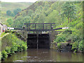
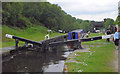
6
Gauxholme Middle Lock
Lock #23, Rochdale Canal.
Image: © Ian S
Taken: 30 May 2012
0.12 miles
7
Gauxholme Middle Lock 23 from above
Rochdale Canal
Image: © Mike Todd
Taken: 15 Jun 2011
0.12 miles