IMAGES TAKEN NEAR TO
Bacup Road, TODMORDEN, OL14 7HT
Introduction
This page details the photographs taken nearby to Bacup Road, OL14 7HT by members of the Geograph project.
The Geograph project started in 2005 with the aim of publishing, organising and preserving representative images for every square kilometre of Great Britain, Ireland and the Isle of Man.

There are currently over 7.5m images from over14,400 individuals and you can help contribute to the project by visiting https://www.geograph.org.uk
Image Map
Images are licensed for reuse under creativecommons.org/licenses/by-sa/2.0
Notes
- Clicking on the map will re-center to the selected point.
- The higher the marker number, the further away the image location is from the centre of the postcode.
Image Listing (36 Images Found)
Images are licensed for reuse under creativecommons.org/licenses/by-sa/2.0
Image
Details
Distance

2
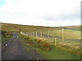
Drainage works
From Limer's Gate path; the observatory is just visible in the middle of the picture.
Image: © Dave Dunford
Taken: 11 Sep 2011
0.09 miles
3
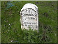
A681 Bacup Todmorden Road Mileage Stone
Taken 310507. Stone situated on North side of road
Image: © Robert Wade
Taken: 31 May 2007
0.10 miles
4
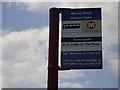
Moorland Bus Stop A681 Lancashire Yorkshire Border
Never seen a queue
Image: © Robert Wade
Taken: 31 May 2007
0.11 miles
5
New fencing along Limers Gate
A barbed wire fence and a high deer fence to keep people/animals in or out of South Grain Farm. Bridleway users have been provided with a high stile over the fences
Image: © John Slater
Taken: 19 Jan 2012
0.12 miles
6
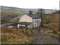
Holden Gate
This house is on the A681 west of Todmorden. It is being approached here via the bridleway from Flowerscar Road.
Image: © michael ely
Taken: 23 Jan 2006
0.12 miles
7

Old milestone
On the east side of the road near a pair of cream coloured semis at Holden Gate is this chunky milestone, the only one of this size around Todmorden. After about another ½ mile the A681 leaves Yorkshire and enters Lancashire. There is a defaced bench mark at the base. In 2002 it was found leaning and in need of a coat of paint. In 2004 it was set upright. Grade II listed 339003.
Image: © Robert Glover
Taken: 9 Nov 2020
0.13 miles

9
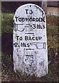
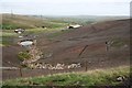
Old Milestone, A681, Bacup Road, Holden Gate
Located on the East side of road, on verge in front of a pair of cream fronted semis. Carved stone post, Todmorden round top design, erected by Todmorden turnpike trust, 18th/19th century.
Inscription reads: TO / TODMORDEN / {hand to right} 3 MLS / line / TO BACUP / 2 ¼ MLS {hand to left} /line
Grade II listed by Historic England. see https://historicengland.org.uk/listing/the-list/list-entry/1185405
Milestone Society National ID: YW_TOBP03
Image: © Christine Minto
Taken: 4 Feb 2006
0.13 miles
10
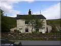
Pair of Cottages A681 Bacup Todmorden Road
East of the Lancashire Yorkshire border. South facing cottages near the Astronomy centre.
Image: © Robert Wade
Taken: 31 May 2007
0.13 miles