IMAGES TAKEN NEAR TO
Tower Street, TODMORDEN, OL14 7EN
Introduction
This page details the photographs taken nearby to Tower Street, OL14 7EN by members of the Geograph project.
The Geograph project started in 2005 with the aim of publishing, organising and preserving representative images for every square kilometre of Great Britain, Ireland and the Isle of Man.

There are currently over 7.5m images from over14,400 individuals and you can help contribute to the project by visiting https://www.geograph.org.uk
Image Map
Images are licensed for reuse under creativecommons.org/licenses/by-sa/2.0
Notes
- Clicking on the map will re-center to the selected point.
- The higher the marker number, the further away the image location is from the centre of the postcode.
Image Listing (53 Images Found)
Images are licensed for reuse under creativecommons.org/licenses/by-sa/2.0
Image
Details
Distance
1
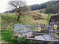
The bottom of Tower Clough
A tributary of the Yorkshire Calder, which flows most of the way through Portsmouth and Cornholme in culvert.
Image: © Stephen Craven
Taken: 2 May 2022
0.03 miles
2
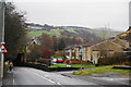
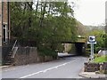
The A646 between Portsmouth and Cornholme
It is shortly to go under a railway bridge.
Image: © Bill Boaden
Taken: 24 Dec 2011
0.03 miles
3
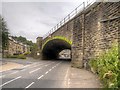
Railway Bridge Over Burnley Road near Cornholme
Image: © David Dixon
Taken: 26 Jun 2014
0.05 miles
4
Railway bridge over Burnley Road (A646), Cornholme, Todmorden
Image: © JThomas
Taken: 26 Nov 2016
0.05 miles
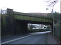
5
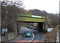
Upper railway bridge over Burnley Road
There are several railway bridges in this area, as the narrow valley bottom forces the railway, main road and side roads to compete for space. This one is distinguished from the one lower down the hill Image by its stone arch having been replaced by a steel deck, probably to give higher clearance to road vehicles.
Image: © Stephen Craven
Taken: 2 May 2022
0.05 miles
6
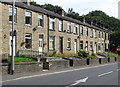
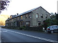
Portsmouth - terrace on Burnley Road
At the eastern end of Portsmouth.
Image: © Dave Bevis
Taken: 26 Jul 2014
0.05 miles
7
Railway Bridge, Cornholme
The railway crosses the A646, Burnley Road, twice in Cornholme. This bridge is the westernmost towards the outskirts of the village. Shot taken from Mount Pleasant Street.
Image: © michael ely
Taken: 14 Mar 2008
0.07 miles
8
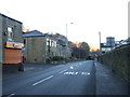
Bus stop on Burnley Road, Cornholme, Todmorden
Image: © JThomas
Taken: 26 Nov 2016
0.07 miles
9
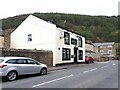
The Glen View Inn, Burnley Road, Portsmouth
The westernmost of the pubs in this collection (see Shared Description), less than half a mile from the present Lancashire border. It was immediately adjacent to Carrfield cotton mill (to the left, now replaced by housing) whose workers would no doubt have deserved a drink after work. Note the Tetley signage; although that Leeds brewery no longer exists, the brand does and the pub still serves it.
Image: © Stephen Craven
Taken: 2 May 2022
0.08 miles
10
Terraced housing on Burnley Road (A646), Cornholme
Image: © JThomas
Taken: 26 Nov 2016
0.08 miles