IMAGES TAKEN NEAR TO
Burnley Road, TODMORDEN, OL14 7BU
Introduction
This page details the photographs taken nearby to Burnley Road, OL14 7BU by members of the Geograph project.
The Geograph project started in 2005 with the aim of publishing, organising and preserving representative images for every square kilometre of Great Britain, Ireland and the Isle of Man.

There are currently over 7.5m images from over14,400 individuals and you can help contribute to the project by visiting https://www.geograph.org.uk
Image Map
Images are licensed for reuse under creativecommons.org/licenses/by-sa/2.0
Notes
- Clicking on the map will re-center to the selected point.
- The higher the marker number, the further away the image location is from the centre of the postcode.
Image Listing (658 Images Found)
Images are licensed for reuse under creativecommons.org/licenses/by-sa/2.0
Image
Details
Distance

3
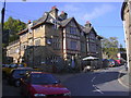
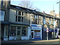
"The White Hart Hotel" White Hart Fold, Todmorden, Yorkshire, OL14 7BD
Image: © Robert Wade
Taken: 11 Oct 2010
0.01 miles
8
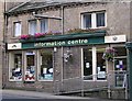
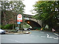
Burnley Road
Ridge Road branching off to the left.
Image: © Stanley Walker
Taken: 17 Jul 2007
0.02 miles
9
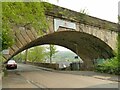
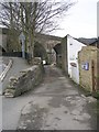
Railway arch over Ridge Road
This is the southernmost arch of Todmorden railway viaduct, built c.1840 by George Stephenson for the Manchester and Leeds Railway.
Image: © Stephen Craven
Taken: 2 May 2022
0.02 miles
10
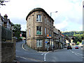
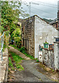
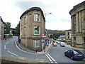
Todmorden - Burnley Road / Ridge Road
Taken from the corner of Burnley Road and Ridge Road in the town centre, the former carries on before curving around to the left and passing under the impressive viaduct and past the bus station, while the latter snakes round to the left upwards towards Station Approach and the station itself.
Image: © David Ward
Taken: 24 Jul 2007
0.02 miles