IMAGES TAKEN NEAR TO
Ridge Road, TODMORDEN, OL14 7AX
Introduction
This page details the photographs taken nearby to Ridge Road, OL14 7AX by members of the Geograph project.
The Geograph project started in 2005 with the aim of publishing, organising and preserving representative images for every square kilometre of Great Britain, Ireland and the Isle of Man.

There are currently over 7.5m images from over14,400 individuals and you can help contribute to the project by visiting https://www.geograph.org.uk
Image Map
Images are licensed for reuse under creativecommons.org/licenses/by-sa/2.0
Notes
- Clicking on the map will re-center to the selected point.
- The higher the marker number, the further away the image location is from the centre of the postcode.
Image Listing (635 Images Found)
Images are licensed for reuse under creativecommons.org/licenses/by-sa/2.0
Image
Details
Distance
1
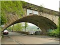
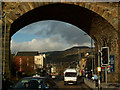
Railway arch over Ridge Road
This is the southernmost arch of Todmorden railway viaduct, built c.1840 by George Stephenson for the Manchester and Leeds Railway.
Image: © Stephen Craven
Taken: 2 May 2022
0.02 miles
3

Train coming off Todmorden viaduct
The line was opened by the Manchester and Leeds Railway in 1840 and passed through the hands of the Lancashire and Yorkshire, London Midland & Scottish Railway and eventually British Rail. Trains are currently operated by Northern Railway (a publicly owned company). This recently introduced Civity diesel unit (195132) is operating a service to Manchester Victoria.
Image: © Stephen Craven
Taken: 2 May 2022
0.02 miles
4
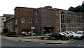
Todmorden Community College - Burnley Road
Image: © Betty Longbottom
Taken: 29 Aug 2007
0.03 miles
5
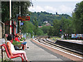
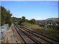
Todmorden - view NE from station
For a similar view taken by Dr Neil Clifton in 1990, please see Image Cross Stone Church tower is still visible on the sky-line.
Image: © Dave Bevis
Taken: 26 Jul 2014
0.03 miles
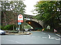
6
Burnley Road and railway viaduct, Todmorden
The viaduct was constructed in the late 1830s to carry the Manchester & Leeds Railway, now the Caldervale line. The bus station is just to the right.
Image: © Phil Champion
Taken: 14 Jan 2006
0.04 miles
7
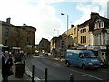
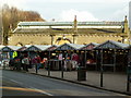
Burnley Road, Todmorden Town Centre
The railway viaduct and bus station are behind the camera. The outdoor market can just be seen to the left of the photos. In the distance can be seen the back end of Todmorden Town Hall and the chancel of St Mary's church.
Image: © Phil Champion
Taken: 14 Jan 2006
0.04 miles
10
Railway line east of Todmorden station
Looking towards Bradford and Leeds (and now Burnley) from the end of platform 2 of Todmorden station. The 1241 departure to Leeds via Bradford, formed of a pair of class 142 diesel units, has just rolled onto the viaduct carrying the railway across the town. The rooftops visible on the right give an idea of how high up the railway is at this point.
Image: © Richard Vince
Taken: 19 Sep 2017
0.04 miles