IMAGES TAKEN NEAR TO
Lacy Avenue, TODMORDEN, OL14 6RP
Introduction
This page details the photographs taken nearby to Lacy Avenue, OL14 6RP by members of the Geograph project.
The Geograph project started in 2005 with the aim of publishing, organising and preserving representative images for every square kilometre of Great Britain, Ireland and the Isle of Man.

There are currently over 7.5m images from over14,400 individuals and you can help contribute to the project by visiting https://www.geograph.org.uk
Image Map
Images are licensed for reuse under creativecommons.org/licenses/by-sa/2.0
Notes
- Clicking on the map will re-center to the selected point.
- The higher the marker number, the further away the image location is from the centre of the postcode.
Image Listing (128 Images Found)
Images are licensed for reuse under creativecommons.org/licenses/by-sa/2.0
Image
Details
Distance

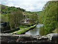
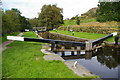
3
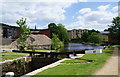
Lock 27 on the Rochdale Canal
This is near the middle of Walsden, and several of its buildings can be seen here.
Image: © Bill Boaden
Taken: 12 Jun 2010
0.01 miles
5
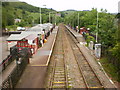
Walsden Railway Station from footbridge
Image: © Alexander P Kapp
Taken: 9 Jun 2009
0.04 miles
6
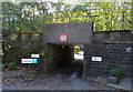
Low railway bridge, Walsden
Provides disabled access to Platform 2, Walsden Railway Station.
Image: © JThomas
Taken: 18 Oct 2018
0.04 miles
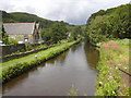
7
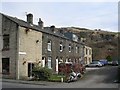
Houses in Granville Street, Walsden
Seen from Alma Bridge, on the Rochdale Canal.
Image: © Christine Johnstone
Taken: 6 May 2014
0.04 miles
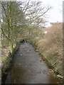
9
Pinnel Lock, Rochdale Canal near Walsden
Image: © Phil Champion
Taken: 25 Sep 2006
0.05 miles