IMAGES TAKEN NEAR TO
Long Hey Lane, TODMORDEN, OL14 6JN
Introduction
This page details the photographs taken nearby to Long Hey Lane, OL14 6JN by members of the Geograph project.
The Geograph project started in 2005 with the aim of publishing, organising and preserving representative images for every square kilometre of Great Britain, Ireland and the Isle of Man.

There are currently over 7.5m images from over14,400 individuals and you can help contribute to the project by visiting https://www.geograph.org.uk
Image Map
Images are licensed for reuse under creativecommons.org/licenses/by-sa/2.0
Notes
- Clicking on the map will re-center to the selected point.
- The higher the marker number, the further away the image location is from the centre of the postcode.
Image Listing (19 Images Found)
Images are licensed for reuse under creativecommons.org/licenses/by-sa/2.0
Image
Details
Distance
1
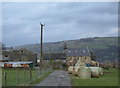
Longfield Farm, Todmorden
Typical of many farms on the agricultural shelf above the Calder valley.
Image: © michael ely
Taken: 15 Feb 2007
0.09 miles
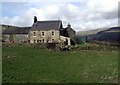
2
Lower Longfield Farm, above Todmorden
Photo taken from Shoebroad Lane
Image: © Phil Champion
Taken: 6 May 2007
0.11 miles

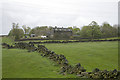
4
Longfield, Todmorden
Longfield Farm on the Calderdale Way between Todmorden and Lumbutts.
Image: © Paul Glazzard
Taken: 8 Mar 2007
0.14 miles
5
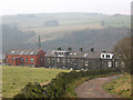
Longfield Terrace, Todmorden
The highest street in this part of the town, Longfield Terrace provides an interesting contrast between the older stone and slightly newer brick terraces. The photo is taken from the bridleway known as Longfield Road.
Image: © Stephen Craven
Taken: 30 Dec 2008
0.15 miles

7

Shewbread, Quaker Burial Ground, c1668, Gate
Image: © Alexander P Kapp
Taken: 15 Oct 2008
0.19 miles
8

Stone
In the wall at Shewbread, Quaker Burial Ground c1668
Image: © Alexander P Kapp
Taken: 15 Oct 2008
0.19 miles
9
Shewbread, Quaker Burial Ground, c1668
Image: © Alexander P Kapp
Taken: 15 Oct 2008
0.19 miles
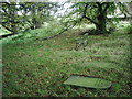
10

Shewbread, Quaker Burial Ground, c1668
Image: © Alexander P Kapp
Taken: 15 Oct 2008
0.19 miles