IMAGES TAKEN NEAR TO
Stoodley Lane, TODMORDEN, OL14 6HA
Introduction
This page details the photographs taken nearby to Stoodley Lane, OL14 6HA by members of the Geograph project.
The Geograph project started in 2005 with the aim of publishing, organising and preserving representative images for every square kilometre of Great Britain, Ireland and the Isle of Man.

There are currently over 7.5m images from over14,400 individuals and you can help contribute to the project by visiting https://www.geograph.org.uk
Image Map
Images are licensed for reuse under creativecommons.org/licenses/by-sa/2.0
Notes
- Clicking on the map will re-center to the selected point.
- The higher the marker number, the further away the image location is from the centre of the postcode.
Image Listing (82 Images Found)
Images are licensed for reuse under creativecommons.org/licenses/by-sa/2.0
Image
Details
Distance
1
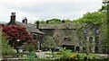
Stoodley Hall and Cottages
An historic building complex including residential, farmhouse and industrial. It stands at the side of Stoodley Clough
Image: © Kevin Waterhouse
Taken: 27 May 2021
0.01 miles
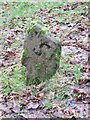
2

Old Boundary Marker in Stoodley Glen, Calderdale
Township Boundary Marker above Stoodley Glen and south of Stoodley Lane. Formerly on the boundary of Langfield and Sowerby townships in Halifax parish. It marked the boundary of the Sowerby Ramble, a narrow strip of land along the Calder valley and up Stoodley Glen between Erringden and Stansfield townships and Erringden and Langfield township. Sowerby Ramble was part of Sowerby township but in 1850 it became part of Erringden township, later parish. In 1897 Langfield and Stansfield became part of Todmorden parish and in 1937 this part of Erringden parish also became part of Todmorden parish.
Milestone Society National ID: YW_LANSOW02pb
Image: © C Chatham
Taken: 10 Jan 2022
0.05 miles
3
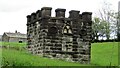
Castellated Outbuilding
At Stoodley Hall with an unknown purpose. Two buildings nearby are the Coach House and Wash House, also water troughs in the lane, so could it have some involvement in water supply? However it certainly looks the part of a folly
Image: © Kevin Waterhouse
Taken: 27 May 2021
0.07 miles
4
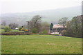
Stoodley Lane
The Coach House and Buildings near Stoodley Hall
Image: © Kevin Rushton
Taken: 16 Apr 2009
0.07 miles
5
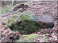
Old Boundary Marker in Stoodley Wood, Todmorden
Parish Boundary Marker in Stoodley Wood between Stoodley Lane and Stoodley Clough. Formerly on the boundary of Langfield and Sowerby townships in Halifax parish. It marked the boundary of the Sowerby Ramble, a narrow strip of land along the Calder valley and up Stoodley Glen between Erringden and Stansfield townships and Erringden and Langfield townships. Sowerby Ramble was part of Sowerby township but in 1850 it became part of Erringden township, later parish. In 1897 Langfield and Stansfield became part of Todmorden parish. Damaged during forestry operations in February 2023, see https://www.geograph.org.uk/photo/7418490 for a photo before this.
Milestone Society National ID: YW_LANSOW09pb
Image: © C Chatham
Taken: 26 Feb 2023
0.07 miles
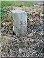
6
Old Boundary Marker in Stoodley Wood, Todmorden
Parish Boundary Marker in Stoodley Wood between Stoodley Lane and Stoodley Clough. Formerly on the boundary of Langfield and Sowerby townships in Halifax parish. It marked the boundary of the Sowerby Ramble, a narrow strip of land along the Calder valley and up Stoodley Glen between Erringden and Stansfield townships and Erringden and Langfield townships. Sowerby Ramble was part of Sowerby township but in 1850 it became part of Erringden township, later parish. In 1897 Langfield and Stansfield became part of Todmorden parish. Damaged during forestry operations in February 2023, see https://www.geograph.org.uk/photo/7418491 for a photo after this.
Milestone Society National ID: YW_LANSOW09pb
Image: © C Chatham
Taken: 1 Apr 2021
0.07 miles
7

Concrete Access Lane in Stoodley Clough
Adopted by a bridleway descending towards the Rochdale Canal
Image: © Chris Heaton
Taken: 7 Jul 2019
0.07 miles
8
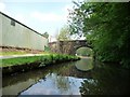
Stoodley Bridge
Bridge no. 24 on the Rochdale Canal.
Image: © Christine Johnstone
Taken: 23 May 2010
0.08 miles
9
Old Boundary Marker in Stoodley Glen, Calderdale
Parish Boundary Marker in Stoodley Glen below Height Wood. Formerly on the boundary of Langfield and Sowerby townships in Halifax parish. It marked the boundary of the Sowerby Ramble, a narrow strip of land along the Calder valley and up Stoodley Glen between Erringden and Stansfield townships and Erringden and Langfield township. Sowerby Ramble was part of Sowerby township but in 1850 it became part of Erringden township, later parish. In 1897 Langfield and Stansfield became part of Todmorden parish and in 1937 this part of Erringden parish also became part of Todmorden parish..
Milestone Society National ID: YW_SOWERR01pb
Image: © C Chatham
Taken: 17 Feb 2022
0.10 miles
10
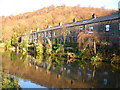
Cottages by the Rochdale Canal, Eastwood
Image: © John H Darch
Taken: 22 Jan 2007
0.10 miles