IMAGES TAKEN NEAR TO
Halifax Road, TODMORDEN, OL14 6EJ
Introduction
This page details the photographs taken nearby to Halifax Road, OL14 6EJ by members of the Geograph project.
The Geograph project started in 2005 with the aim of publishing, organising and preserving representative images for every square kilometre of Great Britain, Ireland and the Isle of Man.

There are currently over 7.5m images from over14,400 individuals and you can help contribute to the project by visiting https://www.geograph.org.uk
Image Map
Images are licensed for reuse under creativecommons.org/licenses/by-sa/2.0
Notes
- Clicking on the map will re-center to the selected point.
- The higher the marker number, the further away the image location is from the centre of the postcode.
Image Listing (59 Images Found)
Images are licensed for reuse under creativecommons.org/licenses/by-sa/2.0
Image
Details
Distance
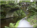
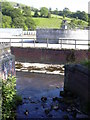
2
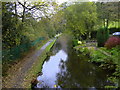
Rochdale Canal at Burnt Acres, Calderdale
Image: © Robert Wade
Taken: 22 Oct 2009
0.16 miles
3
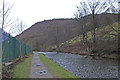
Rochdale Canal at Eastwood
Just before passing the sewage works on the left. Looking towards Hebden Bridge.
Image: © michael ely
Taken: 15 Jan 2015
0.17 miles
4
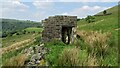
Outbuilding Remains
At Thorps on the path to Oaks Farm
Image: © Kevin Waterhouse
Taken: 1 Jun 2021
0.17 miles
5
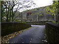
Canal Bridge at Burnt Acres, Calderdale
Image: © Robert Wade
Taken: 22 Oct 2009
0.18 miles
7
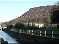
Water treatment works near the River Calder
Image: © JThomas
Taken: 26 Nov 2016
0.19 miles
9

River Calder behind "Murt's Motor Centre" Sandbed, Hebden Bridge, Calderdale, West Yorkshire
I've never seen it as low as this.
Image: © Robert Wade
Taken: 22 Jun 2010
0.19 miles
10
Stream joining the River Calder at Sand Bed
With the water treatment plant in the background
Image: © Robert Wade
Taken: 22 Jun 2010
0.19 miles