IMAGES TAKEN NEAR TO
Halifax Road, TODMORDEN, OL14 6ED
Introduction
This page details the photographs taken nearby to Halifax Road, OL14 6ED by members of the Geograph project.
The Geograph project started in 2005 with the aim of publishing, organising and preserving representative images for every square kilometre of Great Britain, Ireland and the Isle of Man.

There are currently over 7.5m images from over14,400 individuals and you can help contribute to the project by visiting https://www.geograph.org.uk
Image Map
Images are licensed for reuse under creativecommons.org/licenses/by-sa/2.0
Notes
- Clicking on the map will re-center to the selected point.
- The higher the marker number, the further away the image location is from the centre of the postcode.
Image Listing (61 Images Found)
Images are licensed for reuse under creativecommons.org/licenses/by-sa/2.0
Image
Details
Distance
1
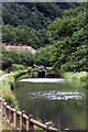
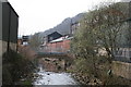
![River Calder [left] and Rochdale Canal [right]](https://s0.geograph.org.uk/geophotos/01/57/43/1574332_392745b0_120x120.jpg)
River Calder [left] and Rochdale Canal [right]
Image: © Christine Johnstone
Taken: 7 Nov 2009
0.02 miles
2
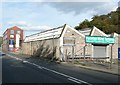
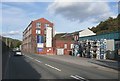
Wind turbine shop, Halifax Road, Stansfield
A growth industry around here.
Image: © Humphrey Bolton
Taken: 1 Oct 2009
0.03 miles
3
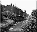
Cottages overhanging the River Calder, near Eastwood
I do not have a name for this row of cottages and would be grateful to anyone who could supply it, also a demolition date, even if approximate.
Image: © Dr Neil Clifton
Taken: 30 Jul 1975
0.05 miles
4
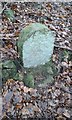
Old Boundary Marker by the Rochdale Canal, Erringden parish
Parish Boundary Marker in Burnt Acres Wood opposite Eastwood on the east bank of the canal, 300 metres southwest of Burnt Acres Lane. Formerly on the boundary of Erringden and Sowerby townships in Halifax parish. It marked the boundary of the Sowerby Ramble, a narrow strip of land along the Calder valley and up Stoodley Glen between Erringden and Stansfield townships and Erringden and Langfield township. Sowerby Ramble was part of Sowerby township, but in 1850 it became part of Erringden township, later parish. The stone is now entirely in Erringden parish.
Milestone Society National ID: YW_ERRING01pb
Image: © D Garside
Taken: 11 Jan 2018
0.06 miles
6
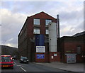
Perseverance Works, Halifax Road, Stansfield
When I saw the spools, I thought perhaps they were for textiles; however Menzolit make "fibre reinforced polyester systems in the form of Sheet Moulding Compound (SMC) are moulded into various parts in a lot of application areas. Typically these are automotive, electrical, construction and sanitary due to their excellent performance regarding heat stability, mechanical and electrical properties" , quoting from their website.
Image: © Humphrey Bolton
Taken: 1 Oct 2009
0.09 miles
7
River Calder near Eastwood
Even in its infancy this river is surrounded by industrial premises
Image: © Dr Neil Clifton
Taken: 12 Apr 2007
0.09 miles
8
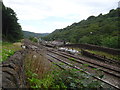
Eastwood railway station (site), Yorkshire
Opened in 1840 by the Manchester & Leeds Railway, later part of the Lancashire & Yorkshire Railway, this station closed to passengers in 1951 and completely in 1964.
View north east. The Leeds-bound platform was at the bottom of the image, the Manchester-bound platform was to the right of the track beyond the foot crossing. The main building was to the left of the image beyond the foot crossing. No trace apparently remains.
Image: © Nigel Thompson
Taken: 17 Jul 2018
0.10 miles
9

Totem pole on Carved Earth workshop, Halifax Road, Eastwood
The Carved Earth website has the address as Brearley Lane, Luddendenfoot, so it appears that they have moved to here recently.
Image: © Humphrey Bolton
Taken: 11 Dec 2012
0.10 miles