IMAGES TAKEN NEAR TO
Upper Shaw Wood Road, TODMORDEN, OL14 6BH
Introduction
This page details the photographs taken nearby to Upper Shaw Wood Road, OL14 6BH by members of the Geograph project.
The Geograph project started in 2005 with the aim of publishing, organising and preserving representative images for every square kilometre of Great Britain, Ireland and the Isle of Man.

There are currently over 7.5m images from over14,400 individuals and you can help contribute to the project by visiting https://www.geograph.org.uk
Image Map
Images are licensed for reuse under creativecommons.org/licenses/by-sa/2.0
Notes
- Clicking on the map will re-center to the selected point.
- The higher the marker number, the further away the image location is from the centre of the postcode.
Image Listing (16 Images Found)
Images are licensed for reuse under creativecommons.org/licenses/by-sa/2.0
Image
Details
Distance
1
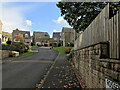
Rossendale View, Mankinholes
Modern residential development on the slopes above Todmorden.
Image: © David Dixon
Taken: 7 Oct 2020
0.07 miles
4
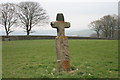
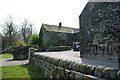
Mankinholes , Cross lane
Stone Cross at Mankinholes Tops
Image: © Kevin Rushton
Taken: 16 Apr 2009
0.17 miles
5
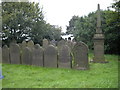
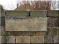
Mankinholes Methodist Church Burial Ground
The church itself closed in 1979.
Image: © David Watson
Taken: 14 Sep 2008
0.21 miles
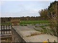
7

Lobb Stables from the Horsfall Tunnel, Todmorden
Looking across the valley
Image: © Robert Wade
Taken: 25 Mar 2011
0.22 miles
8
Site of the former Mankinholes Methodist Church
Image: © Michael Steele
Taken: 21 Apr 2014
0.22 miles
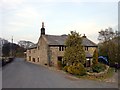
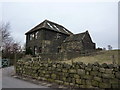
9

Farm Building, newly extended and converted for residential use
Image: © Michael Steele
Taken: 21 Apr 2014
0.23 miles