IMAGES TAKEN NEAR TO
Lower Ferney Lee, TODMORDEN, OL14 5JS
Introduction
This page details the photographs taken nearby to Lower Ferney Lee, OL14 5JS by members of the Geograph project.
The Geograph project started in 2005 with the aim of publishing, organising and preserving representative images for every square kilometre of Great Britain, Ireland and the Isle of Man.

There are currently over 7.5m images from over14,400 individuals and you can help contribute to the project by visiting https://www.geograph.org.uk
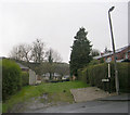
Image Map
Images are licensed for reuse under creativecommons.org/licenses/by-sa/2.0
Notes
- Clicking on the map will re-center to the selected point.
- The higher the marker number, the further away the image location is from the centre of the postcode.
Image Listing (100 Images Found)
Images are licensed for reuse under creativecommons.org/licenses/by-sa/2.0
Image
Details
Distance
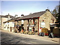
2
The House That Jack Built, Burnley Road
Image: © Robert Wade
Taken: 24 Jan 2009
0.02 miles
4
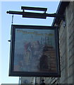
Sign for the House That Jack Built, Todmorden
Also known as Jack's House.
Image: © JThomas
Taken: 26 Nov 2016
0.03 miles
5
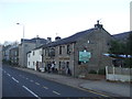
Jack's House, Todmorden
Also known as House That Jack Built.
On Burnley Road.
Image: © JThomas
Taken: 26 Nov 2016
0.03 miles
6
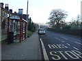
Bus stop and shelter on Burnley Road (A646), Todmorden
Image: © JThomas
Taken: 26 Nov 2016
0.04 miles
8
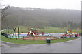
Playground - Centre Vale Park - Burnley Road
Image: © Betty Longbottom
Taken: 30 Mar 2009
0.05 miles