IMAGES TAKEN NEAR TO
Upper Raglan Street, TODMORDEN, OL14 5DU
Introduction
This page details the photographs taken nearby to Upper Raglan Street, OL14 5DU by members of the Geograph project.
The Geograph project started in 2005 with the aim of publishing, organising and preserving representative images for every square kilometre of Great Britain, Ireland and the Isle of Man.

There are currently over 7.5m images from over14,400 individuals and you can help contribute to the project by visiting https://www.geograph.org.uk
Image Map
Images are licensed for reuse under creativecommons.org/licenses/by-sa/2.0
Notes
- Clicking on the map will re-center to the selected point.
- The higher the marker number, the further away the image location is from the centre of the postcode.
Image Listing (311 Images Found)
Images are licensed for reuse under creativecommons.org/licenses/by-sa/2.0
Image
Details
Distance
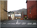
1
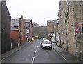
Upper Raglan Street - Whiteplatts Street
Image: © Betty Longbottom
Taken: 30 Mar 2009
0.01 miles
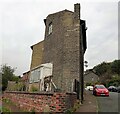
5
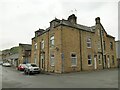
House on the corner of Whiteplatts Street, Todmorden
A grander residence than most in the area, maybe built for a manager of one of the nearby cotton mills.
Image: © Stephen Craven
Taken: 2 May 2022
0.02 miles
6
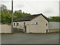
Kingdom Hall, Stansfield Street, Todmorden
A place of worship of the Jehovah's Witnesses.
Image: © Stephen Craven
Taken: 2 May 2022
0.02 miles
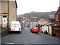
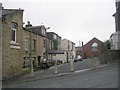
7
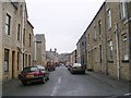
Whiteplatts Street - Stansfield Road
Image: © Betty Longbottom
Taken: 30 Mar 2009
0.02 miles
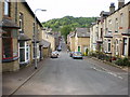
9
Upper Raglan Street - Stansfield Road
Image: © Betty Longbottom
Taken: 30 Mar 2009
0.03 miles
10
Scholefield Street - Stansfield Road
Image: © Betty Longbottom
Taken: 30 Mar 2009
0.03 miles