IMAGES TAKEN NEAR TO
Thames Street, OLDHAM, OL1 3HE
Introduction
This page details the photographs taken nearby to Thames Street, OL1 3HE by members of the Geograph project.
The Geograph project started in 2005 with the aim of publishing, organising and preserving representative images for every square kilometre of Great Britain, Ireland and the Isle of Man.

There are currently over 7.5m images from over14,400 individuals and you can help contribute to the project by visiting https://www.geograph.org.uk
Image Map
Images are licensed for reuse under creativecommons.org/licenses/by-sa/2.0
Notes
- Clicking on the map will re-center to the selected point.
- The higher the marker number, the further away the image location is from the centre of the postcode.
Image Listing (17 Images Found)
Images are licensed for reuse under creativecommons.org/licenses/by-sa/2.0
Image
Details
Distance
1
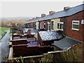
Rear of Charter Street Oldham
One of the many rows of terraced houses with back yards in the Oldham area.
No it's not Coronation Street with Jack and his pigeons!
Image: © Paul Anderson
Taken: 26 Jan 2007
0.08 miles
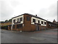
3
Derker Railway Bridge and Station
Derker station is beneath the Railway bridge.
Image: © Paul Anderson
Taken: 6 Jan 2007
0.13 miles
4
Egerton Street at Bridgewater Street, Mumps
Image: © Colin Pyle
Taken: 24 Sep 2021
0.14 miles
5
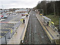
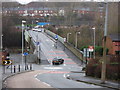
Derker railway / Metrolink station, Greater Manchester
Opened in 1985 by British Rail on the "Oldham Loop" line from Manchester to Rochdale, this station closed in 2009. See Image It was rebuilt and reopened in 2013 as a Metrolink tram stop.
View south towards Oldham and Manchester, following conversion to Metrolink.
Image: © Nigel Thompson
Taken: 30 Dec 2013
0.15 miles
6
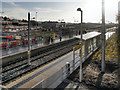
Derker Metrolink Station
The Derker Metrolink Station replaces the former railway station on the “Oldham Loop Line”. It is to the south of the bridge at Yates Street. The former rail station entrances have been closed and new lifts and ramps have been installed.
Image: © David Dixon
Taken: 16 Dec 2012
0.15 miles
7
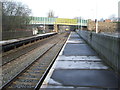
Derker railway / Metrolink station, Greater Manchester
Opened in 1985 by British Rail on the "Oldham Loop" line from Manchester to Rochdale, this station closed in 2009. It was rebuilt and reopened in 2013 as a Metrolink tram stop.
View north towards Royton Junction and Rochdale, when still part of the national rail network.
Image: © Nigel Thompson
Taken: 10 Jan 2009
0.15 miles
8
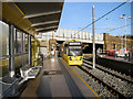
Derker Station
The low sun at this time of year can cause problems for photographers!
Metrolink Bombardier tram number 3003 leaves Derker Station towards Shaw on the day that the Oldham line was extended from Mumps to Shaw and Crompton.
The Derker Metrolink Station replaces the former railway station on the “Oldham Loop Line”. It is to the south of the bridge at Yates Street. The former rail station entrances have been closed and new lifts and ramps have been installed.
Image: © David Dixon
Taken: 16 Dec 2012
0.16 miles
9
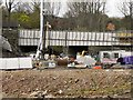
Site of Derker Station
Derker railway station was a railway station on the Oldham Loop Line, and was managed by Northern Rail at the time of closure in 2009. It was originally opened on 30 August 1985 to replace Royton Junction station, ½ mile further along the line.
The station closed on 3 October 2009 for the conversion of the line to Metrolink and will re-open as Derker Metrolink station in 2012.
Image: © David Dixon
Taken: 6 Apr 2011
0.16 miles
10
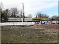
Site Of The Former Derker Railway Station
Derker railway station was a railway station on the Oldham Loop Line, and was managed by Northern Rail at the time of closure in 2009. It was originally opened on 30 August 1985 to replace Royton Junction station, ½ mile further along the line.
The station closed on 3 October 2009 for the conversion of the line to Metrolink and will re-open as Derker Metrolink station in 2012.
Image: © David Dixon
Taken: 6 Apr 2011
0.16 miles