IMAGES TAKEN NEAR TO
Bluebell Walk, St. Marys Way, OLDHAM, OL1 3FR
Introduction
This page details the photographs taken nearby to Bluebell Walk, St. Marys Way, OL1 3FR by members of the Geograph project.
The Geograph project started in 2005 with the aim of publishing, organising and preserving representative images for every square kilometre of Great Britain, Ireland and the Isle of Man.

There are currently over 7.5m images from over14,400 individuals and you can help contribute to the project by visiting https://www.geograph.org.uk
Image Map
Images are licensed for reuse under creativecommons.org/licenses/by-sa/2.0
Notes
- Clicking on the map will re-center to the selected point.
- The higher the marker number, the further away the image location is from the centre of the postcode.
Image Listing (178 Images Found)
Images are licensed for reuse under creativecommons.org/licenses/by-sa/2.0
Image
Details
Distance
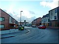
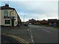
4
Oldham - St Mary's Way From Yorkshire Street
Image: © Peter Whatley
Taken: 16 Sep 2009
0.09 miles
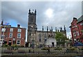
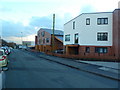
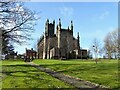
5
St Marys
Built in 1830 by Richard Lane
Image: © Stanley Walker
Taken: 11 Jul 2007
0.11 miles
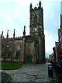
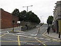
6
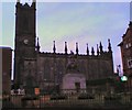
Oldham Parish Church
St Mary's Church from Yorkshire Street.
Image: © Gerald England
Taken: 16 Nov 2009
0.11 miles
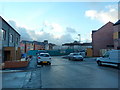
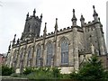
7
Parish Church of St Mary & St Peter
Image: © Kevin Waterhouse
Taken: 9 Feb 2023
0.11 miles