IMAGES TAKEN NEAR TO
Todmorden Road, BACUP, OL13 9UG
Introduction
This page details the photographs taken nearby to Todmorden Road, OL13 9UG by members of the Geograph project.
The Geograph project started in 2005 with the aim of publishing, organising and preserving representative images for every square kilometre of Great Britain, Ireland and the Isle of Man.

There are currently over 7.5m images from over14,400 individuals and you can help contribute to the project by visiting https://www.geograph.org.uk
Image Map
Images are licensed for reuse under creativecommons.org/licenses/by-sa/2.0
Notes
- Clicking on the map will re-center to the selected point.
- The higher the marker number, the further away the image location is from the centre of the postcode.
Image Listing (10 Images Found)
Images are licensed for reuse under creativecommons.org/licenses/by-sa/2.0
Image
Details
Distance

4
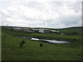
Grazing, Higher Change
View from Todmorden Road (A681).
Image: © JThomas
Taken: 18 Oct 2018
0.13 miles
5
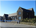
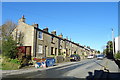
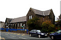
Sharneyford Primary School
On Todmorden Road (A681).
Image: © JThomas
Taken: 18 Oct 2018
0.15 miles
6
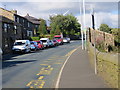
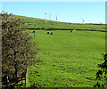
The A681 road at Sharneyford Infants School
Looking north-eastward.
Image: © Peter Wood
Taken: 31 Aug 2014
0.16 miles
7
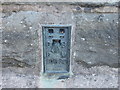
Ordnance Survey Flush Bracket 10839
This can be found on the wall of Sharneyford Infant School.
For more detail see : http://www.bench-marks.org.uk/bm22004
Image: © Peter Wood
Taken: 31 Aug 2014
0.16 miles
8
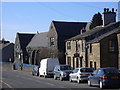
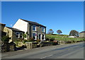
"Sharneyford Primary School" Todmorden Road, Bacup, Lancashire OL13 9UQ
Is this the highest school in Lancashire?
Image: © Robert Wade
Taken: 11 Mar 2010
0.17 miles
9
Bacup: Sharneyford County Primary School
Image: © Dr Neil Clifton
Taken: 15 Oct 2010
0.22 miles