IMAGES TAKEN NEAR TO
Todmorden Road, BACUP, OL13 9UF
Introduction
This page details the photographs taken nearby to Todmorden Road, OL13 9UF by members of the Geograph project.
The Geograph project started in 2005 with the aim of publishing, organising and preserving representative images for every square kilometre of Great Britain, Ireland and the Isle of Man.

There are currently over 7.5m images from over14,400 individuals and you can help contribute to the project by visiting https://www.geograph.org.uk
Image Map
Images are licensed for reuse under creativecommons.org/licenses/by-sa/2.0
Notes
- Clicking on the map will re-center to the selected point.
- The higher the marker number, the further away the image location is from the centre of the postcode.
Image Listing (5 Images Found)
Images are licensed for reuse under creativecommons.org/licenses/by-sa/2.0
Image
Details
Distance
1
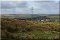
View from the Northern Flanks of Tooter Hill
Image: © Chris Heaton
Taken: 11 Apr 2023
0.16 miles
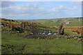
3
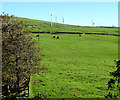
Grazing, Higher Change
View from Todmorden Road (A681).
Image: © JThomas
Taken: 18 Oct 2018
0.23 miles
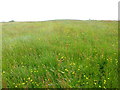
4
Broken Stone Wall on Little Tooter Hill
Image: © Chris Heaton
Taken: 11 Apr 2023
0.23 miles
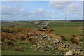
5
Open Gateway on the Flanks of Tooter Hill
Image: © Chris Heaton
Taken: 11 Apr 2023
0.23 miles