IMAGES TAKEN NEAR TO
Hoghton Avenue, BACUP, OL13 9RD
Introduction
This page details the photographs taken nearby to Hoghton Avenue, OL13 9RD by members of the Geograph project.
The Geograph project started in 2005 with the aim of publishing, organising and preserving representative images for every square kilometre of Great Britain, Ireland and the Isle of Man.

There are currently over 7.5m images from over14,400 individuals and you can help contribute to the project by visiting https://www.geograph.org.uk
Image Map
Images are licensed for reuse under creativecommons.org/licenses/by-sa/2.0
Notes
- Clicking on the map will re-center to the selected point.
- The higher the marker number, the further away the image location is from the centre of the postcode.
Image Listing (20 Images Found)
Images are licensed for reuse under creativecommons.org/licenses/by-sa/2.0
Image
Details
Distance
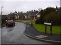
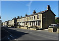
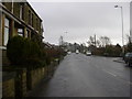
3
Rochdale Road
Towards Bacup. Houghton Avenue is on the left.
Image: © Robert Wade
Taken: 6 Aug 2007
0.07 miles
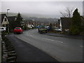
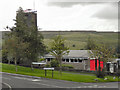
4
Rochdale Road (A671) towards Burnley
Looking north west.
Image: © JThomas
Taken: 10 Oct 2018
0.09 miles
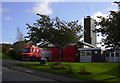
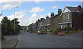
8
Station Court
Built as Fire Brigade houses most have now been sold, formerly Fairview Road.
Image: © Robert Wade
Taken: 24 Oct 2008
0.14 miles
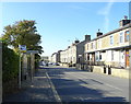
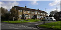
10
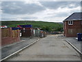
Sandby Close, Bacup
Part of a new housing development of eighty odd houses
Image: © Alexander P Kapp
Taken: 20 May 2008
0.16 miles