IMAGES TAKEN NEAR TO
Britannia Avenue, BACUP, OL13 9JS
Introduction
This page details the photographs taken nearby to Britannia Avenue, OL13 9JS by members of the Geograph project.
The Geograph project started in 2005 with the aim of publishing, organising and preserving representative images for every square kilometre of Great Britain, Ireland and the Isle of Man.

There are currently over 7.5m images from over14,400 individuals and you can help contribute to the project by visiting https://www.geograph.org.uk
Image Map
Images are licensed for reuse under creativecommons.org/licenses/by-sa/2.0
Notes
- Clicking on the map will re-center to the selected point.
- The higher the marker number, the further away the image location is from the centre of the postcode.
Image Listing (88 Images Found)
Images are licensed for reuse under creativecommons.org/licenses/by-sa/2.0
Image
Details
Distance
4
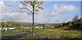
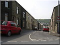
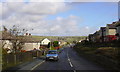
Hawthorn Road
A row of shops that stood in the foreground have been demolished.
Image: © Robert Wade
Taken: 24 Oct 2008
0.07 miles
5
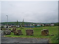
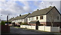
Hawthorn Road playing field
The large stones other than being decorative help the form a barrier as to stop people from driving cars on to the playarea
Image: © Alexander P Kapp
Taken: 30 May 2008
0.09 miles