IMAGES TAKEN NEAR TO
OL13 9AD
Introduction
This page details the photographs taken nearby to OL13 9AD by members of the Geograph project.
The Geograph project started in 2005 with the aim of publishing, organising and preserving representative images for every square kilometre of Great Britain, Ireland and the Isle of Man.

There are currently over 7.5m images from over14,400 individuals and you can help contribute to the project by visiting https://www.geograph.org.uk
Image Map
Images are licensed for reuse under creativecommons.org/licenses/by-sa/2.0
Notes
- Clicking on the map will re-center to the selected point.
- The higher the marker number, the further away the image location is from the centre of the postcode.
Image Listing (360 Images Found)
Images are licensed for reuse under creativecommons.org/licenses/by-sa/2.0
Image
Details
Distance
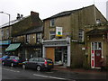
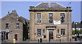
1
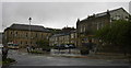
St James Square
The white glazed bricks are the wall of the Conservative Club. The cars are parked on an area where the church was demolished.
Image: © Robert Wade
Taken: 19 Aug 2008
0.01 miles
4
Bacup Mechanics
Library. Yorkshire Street to the left
Image: © Robert Wade
Taken: 10 Jun 2007
0.02 miles
5
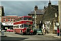
Bus to Accrington, Bacup ? 1973
Bus no.35 of Rossendale Transport approaching the terminal stand on St James Street. Rossendale Transport was formed by a merger of the Rawtenstall and Haslingden bus fleets. It is a Leyland PD3 with East Lancs bodywork, new in 1964. Accrington Corporation was also a partner in the long route between Bacup and Accrington which constituted the core route along the Rossendale valley, the far terminus of which can be seen here https://www.geograph.org.uk/photo/6678643 . The location was little changed in 2011.
This is one of a series of views featuring buses in the 60s, 70s, and 80s. http://www.geograph.org.uk/search.php?i=137652761
Image: © Alan Murray-Rust
Taken: 7 Apr 1973
0.02 miles
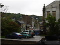
6
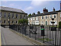
Irwell Terrace Bacup
Mechanics now the library on left.
Image: © Robert Wade
Taken: 10 Jun 2007
0.02 miles
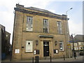
7
Bacup Library (Mechanics Institute) and Irwell Terrace, Bacup
Image: © Robert Wade
Taken: 6 Feb 2011
0.02 miles
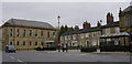
8
Irwell Terrace
The River Irwell is carried through the town centre in a culvert which has just been replaced. The new bus shelters will be arriving soon. To the left is the library formerly The Mechanics Institute.
Image: © Robert Wade
Taken: 19 Aug 2008
0.03 miles
9
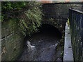
Greave Clough
This is behind the library. The stream has drained the Todmorden Road area of Bacup and is about to join the River Irwell under Bacup centre.
Image: © Robert Wade
Taken: 13 Jan 2009
0.03 miles