IMAGES TAKEN NEAR TO
St. James Square, BACUP, OL13 9AA
Introduction
This page details the photographs taken nearby to St. James Square, OL13 9AA by members of the Geograph project.
The Geograph project started in 2005 with the aim of publishing, organising and preserving representative images for every square kilometre of Great Britain, Ireland and the Isle of Man.

There are currently over 7.5m images from over14,400 individuals and you can help contribute to the project by visiting https://www.geograph.org.uk
Image Map
Images are licensed for reuse under creativecommons.org/licenses/by-sa/2.0
Notes
- Clicking on the map will re-center to the selected point.
- The higher the marker number, the further away the image location is from the centre of the postcode.
Image Listing (348 Images Found)
Images are licensed for reuse under creativecommons.org/licenses/by-sa/2.0
Image
Details
Distance
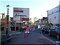
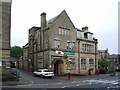
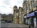
1
St James Square
The roundabout in the centre of town is where the A671 from Rochdale to Burnley meets the A681 from Rawtenstall to Todmorden. The building on the left was originally the King George V pub. Now known as King George Chambers it is offices for an accountancy firm at the front and apartments at the rear. The Art Deco building in the middle was used as council offices It later became an electricity showroom and then a community resource centre. Now it is a hair salon. The brick building on the right was originally Woolworths.
Image: © Gerald England
Taken: 6 Aug 2022
0.01 miles
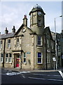
2
King George V Bacup
Now flats. Burnley Road is on the left of the building and Yorkshire Street leading to Todmorden Road is to the right.
Image: © Robert Wade
Taken: 10 Jun 2007
0.01 miles
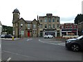
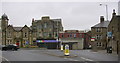
3
Bacup Bingo Hall, Burnley Road, Bacup
Awaiting development
Image: © Robert Wade
Taken: 6 Feb 2011
0.01 miles
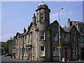
5

King George V, St James Square
Built as a public house it has now been converted to flats. The road to the left is Burnley Road.
Image: © Robert Wade
Taken: 5 Aug 2008
0.01 miles
6
St James Square
A mixture of styles, the red brick building was Woolworths, it has now been declared unsafe
Image: © Robert Wade
Taken: 6 Feb 2011
0.01 miles
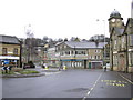
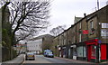
9
Bacup: Town Centre (St James' Square)
Taken from the bottom of Yorkshire Street. Burnley Road (A671) goes up to the right, while straight on is Market Street, the road to Rawtenstall (A681).
Image: © Dr Neil Clifton
Taken: 12 Apr 2011
0.02 miles