IMAGES TAKEN NEAR TO
Bent Estate, BACUP, OL13 8QY
Introduction
This page details the photographs taken nearby to Bent Estate, OL13 8QY by members of the Geograph project.
The Geograph project started in 2005 with the aim of publishing, organising and preserving representative images for every square kilometre of Great Britain, Ireland and the Isle of Man.

There are currently over 7.5m images from over14,400 individuals and you can help contribute to the project by visiting https://www.geograph.org.uk
Image Map
Images are licensed for reuse under creativecommons.org/licenses/by-sa/2.0
Notes
- Clicking on the map will re-center to the selected point.
- The higher the marker number, the further away the image location is from the centre of the postcode.
Image Listing (30 Images Found)
Images are licensed for reuse under creativecommons.org/licenses/by-sa/2.0
Image
Details
Distance
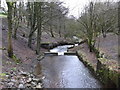
2
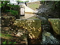
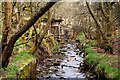
River Irwell in Weir, Lancashire
The River Irwell at Weir, Lancashire, England. Here, close to its source (which is a little further north, at Cliviger), the Irwell is little more than a stream.
Image: © Steven Haslington
Taken: 26 Oct 2009
0.06 miles
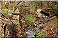
5
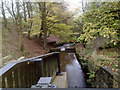
The infant River Irwell
This photograph was taken just downstream of the site of Irwell Springs Bleach, Dye and Print works. When this works (now demolished) was in business, the Irwell was already heavily polluted at this point with effluent. Now it runs clean here, at the start of its journey which will take it through Bacup, then down the Rossendale Valley to Rawtenstall, thence to Bury and on southwards to the great city of Manchester, where most of its water will disgorge into the Manchester Ship Canal and finally find its way into the Mersey estuary and the Irish Sea.
To see a map of what this gridsquare (and others nearby) was like in earlier years, see http://www.nearby.org.uk/geograph/media/public.php?profile=139
Image: © Dr Neil Clifton
Taken: 15 Apr 2009
0.07 miles
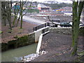
7
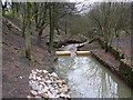
The infant River Irwell (2)
See also Image Settling tanks were located just upstream of this point, on the left side. They removed solid particles, but soluble pollutants were not removed and persisted until the works had closed. For maps showing what this and other nearby squares were like in earlier times, see http://www.nearby.org.uk/geograph/media/view.php?id=571
Image: © Dr Neil Clifton
Taken: 15 Apr 2009
0.07 miles
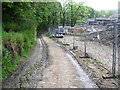
8
River Irwell
The print works have now been demolished and a housing development is under way
Image: © Robert Wade
Taken: 20 Jan 2008
0.08 miles
9
River Irwell at Irwell Springs, Rossendale
Image: © Robert Wade
Taken: 6 Feb 2011
0.09 miles
10

New housing development on Beaufort Road, Weir
In the current economic climate, such housing development is rare. However it is said locally that you get more house for your money in Weir.
Image: © Bill Boaden
Taken: 29 Apr 2011
0.09 miles