IMAGES TAKEN NEAR TO
Taylor Holme Industrial Estate, Atherton Way, BACUP, OL13 0LE
Introduction
This page details the photographs taken nearby to Taylor Holme Industrial Estate, Atherton Way, OL13 0LE by members of the Geograph project.
The Geograph project started in 2005 with the aim of publishing, organising and preserving representative images for every square kilometre of Great Britain, Ireland and the Isle of Man.

There are currently over 7.5m images from over14,400 individuals and you can help contribute to the project by visiting https://www.geograph.org.uk
Image Map
Images are licensed for reuse under creativecommons.org/licenses/by-sa/2.0
Notes
- Clicking on the map will re-center to the selected point.
- The higher the marker number, the further away the image location is from the centre of the postcode.
Image Listing (60 Images Found)
Images are licensed for reuse under creativecommons.org/licenses/by-sa/2.0
Image
Details
Distance

2
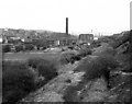
The next train left some time ago: Stacksteads, Lancashire
This shows the trackbed of the railway along the Rossendale Valley, looking towards Bacup. Already in 1976 the cotton industry, which had sustained the valley for the last two centuries, was played out. So, of course, the good Dr Beeching helped the people of this community by removing their rail link to Bury and Manchester, where some of them might have been able to find employment.
Image: © Dr Neil Clifton
Taken: 15 Apr 1976
0.06 miles
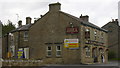
6

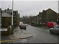
Newchurch Road, Stacksteads
Passing the turn off to the industrial estate (on the left).
Image: © David Dixon
Taken: 27 Aug 2010
0.07 miles
8
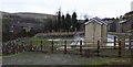
Sewer Flood Prevention Scheme
Work is almost finished on this multi million pound project to prevent pollution of the River Irwell
Image: © Robert Wade
Taken: 6 Feb 2011
0.08 miles
9
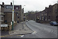
Newchurch Road
Newchurch Road at the corner of Baldwin Street, towards Waterfoot.
Image: © Darren Singleton
Taken: 7 Mar 2007
0.08 miles
10
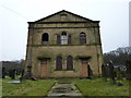
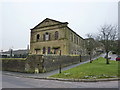
Waterbarn Baptist Church
Looking at the state of this part of the building it has not been used as one for many years. The church services are conducted in the rear of building which probably was the Sunday school when first built.
Image: © Alexander P Kapp
Taken: 3 Feb 2010
0.08 miles