IMAGES TAKEN NEAR TO
Stubbylee Lane, BACUP, OL13 0DD
Introduction
This page details the photographs taken nearby to Stubbylee Lane, OL13 0DD by members of the Geograph project.
The Geograph project started in 2005 with the aim of publishing, organising and preserving representative images for every square kilometre of Great Britain, Ireland and the Isle of Man.

There are currently over 7.5m images from over14,400 individuals and you can help contribute to the project by visiting https://www.geograph.org.uk
Image Map
Images are licensed for reuse under creativecommons.org/licenses/by-sa/2.0
Notes
- Clicking on the map will re-center to the selected point.
- The higher the marker number, the further away the image location is from the centre of the postcode.
Image Listing (39 Images Found)
Images are licensed for reuse under creativecommons.org/licenses/by-sa/2.0
Image
Details
Distance
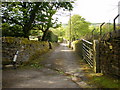
1
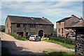
Bacup: The real Moss Meadows Farm
As so named on Ordnance Survey maps.
Image: © Dr Neil Clifton
Taken: 28 Jun 2011
0.01 miles
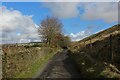
6
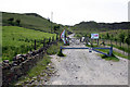
Bacup: Course of old tramway
Looking south (uphill) towards Lee Quarry. This tramway was used for transporting stone down to the East Lancashire (later L&Y) railway at Holt's Siding, where the stone was trans-shipped into railway wagons for onward transport.
Image: © Dr Neil Clifton
Taken: 28 Jun 2011
0.13 miles
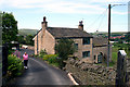
7
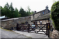
Bacup: Stubbylee Meadows Farm
The owner of this property has affixed various notices giving warning of the dire consequences which would fall upon any encroacher on the property; he has also affixed a notice stating that it is Moss Meadows Farm. There are strong reasons, however, to believe that the real name is Stubbylee Meadows Farm.
Image: © Dr Neil Clifton
Taken: 28 Jun 2011
0.14 miles
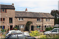
9
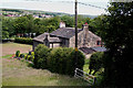
Bacup: Stubbylee Meadows Farm
This is the same farm as shown on Image, but here seen from above, on the Rossendale Way footpath.
Image: © Dr Neil Clifton
Taken: 28 Jun 2011
0.15 miles