IMAGES TAKEN NEAR TO
Plantation Mill Industrial Estate, Market Street, BACUP, OL13 0BN
Introduction
This page details the photographs taken nearby to Plantation Mill Industrial Estate, Market Street, OL13 0BN by members of the Geograph project.
The Geograph project started in 2005 with the aim of publishing, organising and preserving representative images for every square kilometre of Great Britain, Ireland and the Isle of Man.

There are currently over 7.5m images from over14,400 individuals and you can help contribute to the project by visiting https://www.geograph.org.uk
Image Map
Images are licensed for reuse under creativecommons.org/licenses/by-sa/2.0
Notes
- Clicking on the map will re-center to the selected point.
- The higher the marker number, the further away the image location is from the centre of the postcode.
Image Listing (128 Images Found)
Images are licensed for reuse under creativecommons.org/licenses/by-sa/2.0
Image
Details
Distance
2
Bacup: Taking a higher view of the 'Swan' and Rockliffe Road
At the south end of Plantation Street, there are some safe modern steps which bring you down to the Market Street level. But there are some other, very precarious, steps which ascend into woodland. Taking great care I climbed these latter steps to obtain this photograph.
Image: © Dr Neil Clifton
Taken: 12 Apr 2011
0.02 miles
3
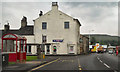
The Swan Hotel, Market Street, Bacup
Image: © Alexander P Kapp
Taken: 20 May 2008
0.02 miles
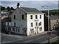
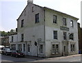
4
Bacup: The 'Swan Hotel'
On Market Street. Photograph taken from Plantation Street
Image: © Dr Neil Clifton
Taken: 12 Apr 2011
0.03 miles
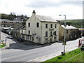
6
Swan Hotel Bacup
Market Street.Rockliffe Road runs up left side of pub
Image: © Robert Wade
Taken: 10 Jun 2007
0.03 miles
7
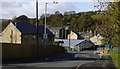
Bacup: Rockliffe Road
This road runs east from Market Street. There seems to be no agreement whether or not there should be a second 'c' in the street name - the Rockcliffe variant appears on the street sign, with the second 'c' whited-out!
Image: © Dr Neil Clifton
Taken: 12 Apr 2011
0.04 miles
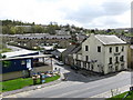
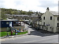
8
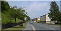
Rockcliffe Road
The new housing on the left are built on the site of the demolished British Legion Club. The modern factory unit was the site of Bacup Railway Station.
Image: © Robert Wade
Taken: 24 Oct 2008
0.04 miles
9
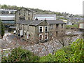
Bacup: View from Plantation Street
Looking southeast
Image: © Dr Neil Clifton
Taken: 12 Apr 2011
0.05 miles
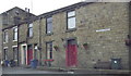
10
Market Street Bacup
looking towards the town centre.The left hand side had been lined with now demolished back to backs
Image: © Robert Wade
Taken: 10 Jun 2007
0.05 miles