IMAGES TAKEN NEAR TO
Henrietta Street, BACUP, OL13 0AR
Introduction
This page details the photographs taken nearby to Henrietta Street, OL13 0AR by members of the Geograph project.
The Geograph project started in 2005 with the aim of publishing, organising and preserving representative images for every square kilometre of Great Britain, Ireland and the Isle of Man.

There are currently over 7.5m images from over14,400 individuals and you can help contribute to the project by visiting https://www.geograph.org.uk
Image Map
Images are licensed for reuse under creativecommons.org/licenses/by-sa/2.0
Notes
- Clicking on the map will re-center to the selected point.
- The higher the marker number, the further away the image location is from the centre of the postcode.
Image Listing (318 Images Found)
Images are licensed for reuse under creativecommons.org/licenses/by-sa/2.0
Image
Details
Distance
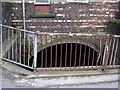
1
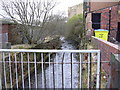
River Irwell
At the Henrietta Street bridge.
Image: © Robert Wade
Taken: 27 Jan 2008
0.01 miles
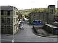
2
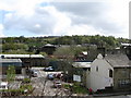
Bacup: View from Plantation Street
Looking east. An Italian restaurant is seen on the right, on Market Street.
Image: © Dr Neil Clifton
Taken: 12 Apr 2011
0.01 miles
3
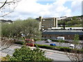
Bacup: View from Plantation Street
Looking northeast.
Image: © Dr Neil Clifton
Taken: 12 Apr 2011
0.02 miles
6
Bacup: Henrietta Street
Seen from Plantation Street
Image: © Dr Neil Clifton
Taken: 12 Apr 2011
0.03 miles
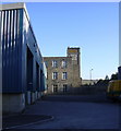
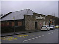
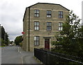
8
Forest Mill, Henrietta Street
http://www.bacuptimes.co.uk/forestmill.htm for further details and its history.
Image: © Robert Wade
Taken: 13 Jan 2009
0.04 miles
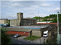
9
Victoria WM Club
Now converted into flats.
Image: © Robert Wade
Taken: 24 Jul 2007
0.04 miles
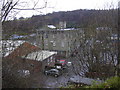
10
Henrietta Street, Bacup
The Irwell disappears again under the Council yard.
Image: © Robert Wade
Taken: 27 Jan 2008
0.04 miles