IMAGES TAKEN NEAR TO
Yasmin Gardens, OLDHAM, OL1 2NP
Introduction
This page details the photographs taken nearby to Yasmin Gardens, OL1 2NP by members of the Geograph project.
The Geograph project started in 2005 with the aim of publishing, organising and preserving representative images for every square kilometre of Great Britain, Ireland and the Isle of Man.

There are currently over 7.5m images from over14,400 individuals and you can help contribute to the project by visiting https://www.geograph.org.uk
Image Map
Images are licensed for reuse under creativecommons.org/licenses/by-sa/2.0
Notes
- Clicking on the map will re-center to the selected point.
- The higher the marker number, the further away the image location is from the centre of the postcode.
Image Listing (20 Images Found)
Images are licensed for reuse under creativecommons.org/licenses/by-sa/2.0
Image
Details
Distance
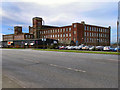
1
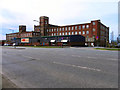
Werneth Mill
Looking across Featherstall Road, towards Werneth Mill.
Image: © David Dixon
Taken: 6 Apr 2011
0.10 miles
3
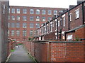
Rear of Eleanor Street Oldham
Much of Oldham's housing stock consists of two-up-two-down Victorian era Accrington red-brick terraced houses in a row formation, built
for the most part from 1870 to 1920, to house the town's cotton mill workers.
A fine example is seen here which shows the back lane to Eleanor Street with the Werneth Ring Mill overshadowing the near by terraced houses.
Image
Image: © Paul Anderson
Taken: 30 Aug 2008
0.11 miles
4

Eleanor Street Oldham
Much of Oldham's housing stock consists of two-up-two-down Victorian era Accrington red-brick terraced houses in a row formation, built for the most part from 1870 to 1920, to house the town's cotton mill workers.
A fine example is seen here on Eleanor Street with the old Werneth Ring Mill overshadowing the near by terraced houses.
For future reference one of these two bedroom houses sold for £69,000 in March 2008.
Image
Image: © Paul Anderson
Taken: 30 Aug 2008
0.11 miles
5
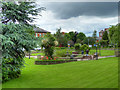
Royal Oldham Hospital, Fountain Gardens
Image: © David Dixon
Taken: 17 Jun 2016
0.17 miles
6
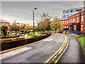
Royal Oldham Hospital, Fountain Gardens
Lying within the Coldhurst area of Oldham on the boundary with Royton, the Royal Oldham Hospital forms part of Pennine Acute Hospitals NHS Trust and was opened with its present name on 1 December 1989; it was formerly known as Oldham and District General Hospital
The hospital is formed by a collection of buildings built in succession since 1851 along Rochdale Road. Its earliest parts exist from the site's time as a local workhouse, having been named Oldham Union Workhouse.
Image: © David Dixon
Taken: 29 Oct 2015
0.18 miles
7
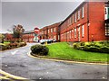
The Education Centre, Royal Oldham Hospital
Lying within the Coldhurst area of Oldham on the boundary with Royton, the Royal Oldham Hospital forms part of Pennine Acute Hospitals NHS Trust and was opened with its present name on 1 December 1989; it was formerly known as Oldham and District General Hospital
The hospital is formed by a collection of buildings built in succession since 1851 along Rochdale Road. Its earliest parts exist from the site's time as a local workhouse, having been named Oldham Union Workhouse.
Image: © David Dixon
Taken: 29 Oct 2015
0.18 miles
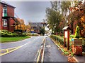
9
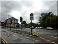
The junction of Featherstall Road and Rochdale Road
Image: © Ian S
Taken: 11 Sep 2010
0.20 miles
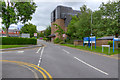
10
Royal Oldham Hospital, Chapel Walk
Lying within the Coldhurst area of Oldham on the boundary with Royton, the Royal Oldham Hospital forms part of Pennine Acute Hospitals NHS Trust and was opened with its present name on 1 December 1989; it was formerly known as Oldham and District General Hospital
The hospital is formed by a collection of buildings built in succession since 1851 along Rochdale Road. Its earliest parts exist from the site's time as a local workhouse, having been named Oldham Union Workhouse.
Image: © David Dixon
Taken: 29 Oct 2015
0.20 miles