IMAGES TAKEN NEAR TO
Lily Street, OLDHAM, OL1 2LD
Introduction
This page details the photographs taken nearby to Lily Street, OL1 2LD by members of the Geograph project.
The Geograph project started in 2005 with the aim of publishing, organising and preserving representative images for every square kilometre of Great Britain, Ireland and the Isle of Man.

There are currently over 7.5m images from over14,400 individuals and you can help contribute to the project by visiting https://www.geograph.org.uk
Image Map
Images are licensed for reuse under creativecommons.org/licenses/by-sa/2.0
Notes
- Clicking on the map will re-center to the selected point.
- The higher the marker number, the further away the image location is from the centre of the postcode.
Image Listing (25 Images Found)
Images are licensed for reuse under creativecommons.org/licenses/by-sa/2.0
Image
Details
Distance
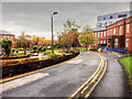
3
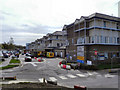
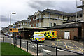
The Royal Oldham Hospital
Royal Parade, at the front of the Royal Oldham Hospital.
Lying within the Coldhurst area of Oldham on the boundary with Royton, the Royal Oldham Hospital forms part of Pennine Acute Hospitals NHS Trust and was opened with its present name on 1 December 1989; it was formerly known as Oldham and District General Hospital
The hospital is formed by a collection of buildings built in succession since 1851 along Rochdale Road. Its earliest parts exist from the site's time as a local workhouse, having been named Oldham Union Workhouse.
Image: © David Dixon
Taken: 6 Apr 2011
0.08 miles
4
Royal Oldham Hospital
Royal Parade, at the front of the Royal Oldham Hospital.
Lying within the Coldhurst area of Oldham on the boundary with Royton, the Royal Oldham Hospital forms part of Pennine Acute Hospitals NHS Trust and was opened with its present name on 1 December 1989; it was formerly known as Oldham and District General Hospital
The hospital is formed by a collection of buildings built in succession since 1851 along Rochdale Road. Its earliest parts exist from the site's time as a local workhouse, having been named Oldham Union Workhouse.
Image: © David Dixon
Taken: 23 Apr 2018
0.08 miles
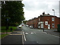
8
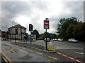
The junction of Featherstall Road and Rochdale Road
Image: © Ian S
Taken: 11 Sep 2010
0.13 miles
9
Royal Oldham Hospital, Fountain Gardens
Lying within the Coldhurst area of Oldham on the boundary with Royton, the Royal Oldham Hospital forms part of Pennine Acute Hospitals NHS Trust and was opened with its present name on 1 December 1989; it was formerly known as Oldham and District General Hospital
The hospital is formed by a collection of buildings built in succession since 1851 along Rochdale Road. Its earliest parts exist from the site's time as a local workhouse, having been named Oldham Union Workhouse.
Image: © David Dixon
Taken: 29 Oct 2015
0.14 miles