IMAGES TAKEN NEAR TO
Ward Street, OLDHAM, OL1 2EQ
Introduction
This page details the photographs taken nearby to Ward Street, OL1 2EQ by members of the Geograph project.
The Geograph project started in 2005 with the aim of publishing, organising and preserving representative images for every square kilometre of Great Britain, Ireland and the Isle of Man.

There are currently over 7.5m images from over14,400 individuals and you can help contribute to the project by visiting https://www.geograph.org.uk
Image Map
Images are licensed for reuse under creativecommons.org/licenses/by-sa/2.0
Notes
- Clicking on the map will re-center to the selected point.
- The higher the marker number, the further away the image location is from the centre of the postcode.
Image Listing (24 Images Found)
Images are licensed for reuse under creativecommons.org/licenses/by-sa/2.0
Image
Details
Distance
1
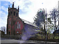
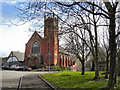
All Saints' Church
The Ukrainian Catholic Church of Saints Peter, Paul and All Saints, Chadderton Way, Northmoor. Formerly All Saints (Church of England) from its consecration in 1891 until it closed and was sold in 1987. (http://www.genuki.org.uk/big/eng/LAN/Oldham/AllSaints.shtml )
See Image]
Image: © David Dixon
Taken: 6 Apr 2011
0.09 miles
3
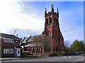
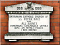
The Ukrainian Catholic Church (All Saints)
The Ukrainian Catholic Church of Saints Peter, Paul and All Saints, Chadderton Way, Northmoor. Formerly All Saints (Church of England) from its consecration in 1891 until it closed and was sold in 1987. (http://www.genuki.org.uk/big/eng/LAN/Oldham/AllSaints.shtml )
See Image]
Image: © David Dixon
Taken: 6 Apr 2011
0.09 miles
5
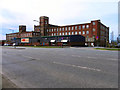
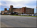
Werneth Mill
Looking across Featherstall Road, towards Werneth Mill.
Image: © David Dixon
Taken: 6 Apr 2011
0.11 miles
6

Eleanor Street Oldham
Much of Oldham's housing stock consists of two-up-two-down Victorian era Accrington red-brick terraced houses in a row formation, built for the most part from 1870 to 1920, to house the town's cotton mill workers.
A fine example is seen here on Eleanor Street with the old Werneth Ring Mill overshadowing the near by terraced houses.
For future reference one of these two bedroom houses sold for £69,000 in March 2008.
Image
Image: © Paul Anderson
Taken: 30 Aug 2008
0.11 miles
7
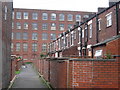
Rear of Eleanor Street Oldham
Much of Oldham's housing stock consists of two-up-two-down Victorian era Accrington red-brick terraced houses in a row formation, built
for the most part from 1870 to 1920, to house the town's cotton mill workers.
A fine example is seen here which shows the back lane to Eleanor Street with the Werneth Ring Mill overshadowing the near by terraced houses.
Image
Image: © Paul Anderson
Taken: 30 Aug 2008
0.11 miles
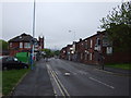
9
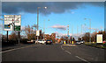
Featherstall Road North Roundabout
Approaching the junction of Featherstall Road North (A6048) with Chadderton Way (A627).
Image: © David Dixon
Taken: 27 Jan 2011
0.12 miles
10
Northmoor Methodist Church
The former Northmoor Methodist Church on Library Lane, closed in the late 1990's (http://www.churches-uk-ireland.org/towns/o/oldham.html ) and now in secular use.
Image: © David Dixon
Taken: 6 Apr 2011
0.13 miles