IMAGES TAKEN NEAR TO
Acorn Way, OLDHAM, OL1 2AY
Introduction
This page details the photographs taken nearby to Acorn Way, OL1 2AY by members of the Geograph project.
The Geograph project started in 2005 with the aim of publishing, organising and preserving representative images for every square kilometre of Great Britain, Ireland and the Isle of Man.

There are currently over 7.5m images from over14,400 individuals and you can help contribute to the project by visiting https://www.geograph.org.uk
Image Map
Images are licensed for reuse under creativecommons.org/licenses/by-sa/2.0
Notes
- Clicking on the map will re-center to the selected point.
- The higher the marker number, the further away the image location is from the centre of the postcode.
Image Listing (74 Images Found)
Images are licensed for reuse under creativecommons.org/licenses/by-sa/2.0
Image
Details
Distance
1
Alphabet House
Day Nursery on Henshaw Street.
Image: © Gerald England
Taken: 13 Oct 2014
0.05 miles
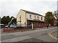
2
The Three C's
On the corner of Henshaw Street and Naylor Street. The three C's (apostrophe included in name whether grammatically correct or not) originally refers to "Coldhurst Conservative Club". Next door is a carpet retailer.
Image: © Gerald England
Taken: 13 Oct 2014
0.06 miles
3
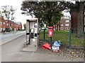
Phone box and post box on Henshaw Street
Although it has no door the phone box appears to be in working order. The postbox is OL1 212.
Image: © Gerald England
Taken: 13 Oct 2014
0.06 miles
4
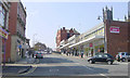
Oldham
Looking westwards up Yorkshire Street towards High Street. The tower of Oldham Parish Church can be seen on the right.
Image: © Martin Clark
Taken: Unknown
0.09 miles
5
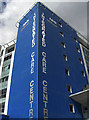
Oldham's Integrated Care Centre
Looking at the corner of this new building from the bus station.
Image: © michael ely
Taken: 22 Apr 2010
0.10 miles
6
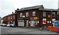
New Museum
The original Museum was a beerhouse opened in 1838 by Samuel Walker on Coldhurst street. Purchased by Oldham Brewery in 1878 it was C.P.O in 1973 and the licence was later transferred to the Brighton Hotel on Henshaw Street in 1975 and the name changed to New Museum.
It has been closed for several years. One half of it has been converted into a Premier convenience store but the other half remains boarded up and for sale.
Image: © Gerald England
Taken: 13 Oct 2014
0.11 miles
7
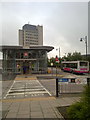
Cheapside, Oldham
Approaching Oldham Bus Station (operated by Transport for Greater Manchester but still displaying branding for the Greater Manchester Passenger Transport Executive), on Cheapside, Oldham, Greater Manchester.
The tall building in the background is Oldham's Civic Centre.
Image: © Steven Haslington
Taken: 21 Jun 2011
0.12 miles
8
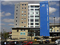
Oldham's Integrated Care Centre
A new NHS facility close to the Civic centre and bus station. The land on which it was built used to be part of a large pay and display car park.
Image: © michael ely
Taken: 22 Apr 2010
0.12 miles
9
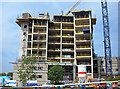
Care Centre under construction
A new £20 million Integrated Care Centre for Oldham is being built on what was a corner of the car park behind the Civic Centre. It is due for completion in 2009.
Image: © michael ely
Taken: 12 May 2008
0.12 miles
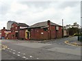
10
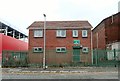
Oldham Army Cadet Force
The Oldham Detachment of the Greater Manchester Army Cadet Force https://armycadets.com/county/greater-manchester-acf/ meet in a building adjacent to the old drill hall.
Image: © Gerald England
Taken: 13 Oct 2014
0.12 miles