IMAGES TAKEN NEAR TO
Green Meadow, ROCHDALE, OL12 9TL
Introduction
This page details the photographs taken nearby to Green Meadow, OL12 9TL by members of the Geograph project.
The Geograph project started in 2005 with the aim of publishing, organising and preserving representative images for every square kilometre of Great Britain, Ireland and the Isle of Man.

There are currently over 7.5m images from over14,400 individuals and you can help contribute to the project by visiting https://www.geograph.org.uk
Image Map (Loading...)


Getting Data...Please wait
Leaflet Map data © OpenStreetMap
Images are licensed for reuse under creativecommons.org/licenses/by-sa/2.0
Notes
- Clicking on the map will re-center to the selected point.
- The higher the marker number, the further away the image location is from the centre of the postcode.
Image Listing (4 Images Found)
Images are licensed for reuse under creativecommons.org/licenses/by-sa/2.0
Image
Details
Distance
1
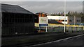
Wardle Academy
May 2013. Buildings for the new Wardle Academy to replace the adjacent Wardle High School, Birch Road, Wardle.
Image: © Peter Thwaite
Taken: 6 May 2013
0.15 miles
2
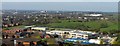
Wardle High School and Academy, Nov 2013
Birch Road, Wardle.
The new buildings for the Wardle Academy lie behind the Wardle High School that it will replace.
Image: © Peter Thwaite
Taken: 1 Nov 2013
0.15 miles
3
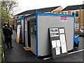
Two Polling Stations
Two portakabins provide separate mobile polling stations for two polling districts in Braddocks Close for the Smallbridge & Firgrove ward of the Borough of Rochdale.
Image: © Peter Thwaite
Taken: 6 May 2010
0.23 miles