IMAGES TAKEN NEAR TO
Bank Lane, ROCHDALE, OL12 9NE
Introduction
This page details the photographs taken nearby to Bank Lane, OL12 9NE by members of the Geograph project.
The Geograph project started in 2005 with the aim of publishing, organising and preserving representative images for every square kilometre of Great Britain, Ireland and the Isle of Man.

There are currently over 7.5m images from over14,400 individuals and you can help contribute to the project by visiting https://www.geograph.org.uk
Image Map (Loading...)


Getting Data...Please wait
Leaflet Map data © OpenStreetMap
Images are licensed for reuse under creativecommons.org/licenses/by-sa/2.0
Notes
- Clicking on the map will re-center to the selected point.
- The higher the marker number, the further away the image location is from the centre of the postcode.
Image Listing (35 Images Found)
Images are licensed for reuse under creativecommons.org/licenses/by-sa/2.0
Image
Details
Distance
1
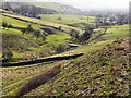
View Towards Wardle From Watergrove
Looking from the embankment at the southern end of Watergrove Reservoir, towards Wardle.
Image: © David Dixon
Taken: 1 Mar 2011
0.10 miles
2
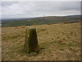
Water Grove trig
Looking SW from position
Image: © Iain Macaulay
Taken: 26 Feb 2006
0.12 miles
3
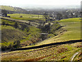
Wardle Brook
Looking across Wardle Brook, towards Wardle, from the eastern end of Watergrove Reservoir.
Image: © David Dixon
Taken: 1 Mar 2011
0.13 miles
4
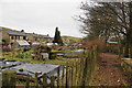
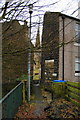
Allotments between the houses
This is just behind Ramsden Road which is the main street through Wardle.
Image: © Bill Boaden
Taken: 31 Dec 2010
0.14 miles
5
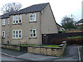
Wardle Fold
An example of warm and comfortable sheltered housing provided by the Anchor Housing Association. These are homes for elderly locals who had once lived elsewhere in the village. Wardle Fold is close to the village square. To see how it looked 42 years ago see Image
Image: © michael ely
Taken: 8 Feb 2008
0.15 miles
6
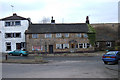
The Globe Inn, Wardle
This old pub, which is the low, grey-stone building in the picture, has I believe recently re-opened after a period of closure. The house is Grade II listed. The beer is said to be Taylor's Landlord, which is real ale of very high quality.
Image: © Dr Neil Clifton
Taken: 29 May 2005
0.16 miles
7
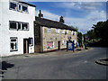
Wardle Village Square
The white building used to be a confectioners shop. Next door was the post office and general store (now shut). The building with the white door is The Globe pub, still open but with no pub sign or name evident. These buildings face the old Methodist chapel on the other side of the square.
Image: © michael ely
Taken: 8 Feb 2008
0.17 miles
8
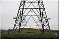
Overhead cables near Wardle
These miss the centre of the village but pass quite close on the northern side. This view is taken from Ramsden Road.
Image: © Bill Boaden
Taken: 31 Dec 2010
0.17 miles
9
Footpath onto Ramsden Road, Wardle
Ramsden Road is the main street, the other side of these houses. St James's Church is behind.
Image: © Bill Boaden
Taken: 31 Dec 2010
0.17 miles
10
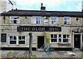
The Globe Inn
On Ramsden Road, Wardle. The 'E' has dropped off.
Image: © michael ely
Taken: 5 Oct 2020
0.18 miles