IMAGES TAKEN NEAR TO
Birch Hill Lane, ROCHDALE, OL12 9LY
Introduction
This page details the photographs taken nearby to Birch Hill Lane, OL12 9LY by members of the Geograph project.
The Geograph project started in 2005 with the aim of publishing, organising and preserving representative images for every square kilometre of Great Britain, Ireland and the Isle of Man.

There are currently over 7.5m images from over14,400 individuals and you can help contribute to the project by visiting https://www.geograph.org.uk
Image Map (Loading...)


Getting Data...Please wait
Leaflet Map data © OpenStreetMap
Images are licensed for reuse under creativecommons.org/licenses/by-sa/2.0
Notes
- Clicking on the map will re-center to the selected point.
- The higher the marker number, the further away the image location is from the centre of the postcode.
Image Listing (18 Images Found)
Images are licensed for reuse under creativecommons.org/licenses/by-sa/2.0
Image
Details
Distance
1
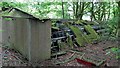
Derelict Poultry Shed
On Middlewood Farm site one of several derelict sheds with battery hen cages
Image: © Kevin Waterhouse
Taken: 4 Jun 2018
0.07 miles
2
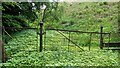
Ornamental Gates near Middlewood Farm
The gates appear to close a carriage drive around East Hill. Which property enjoyed this drive is a mystery
Image: © Kevin Waterhouse
Taken: 4 Jun 2018
0.10 miles
3
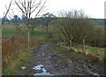
Bridleway between Wardle and Shore
Looking northeast along Pedler Brow Lane. The bridleway changes name to Middle Wood Lane at the right hand bend in the centre of shot. The edge of the village of Shore is about 200 metres around the bend.
Image: © michael ely
Taken: 26 Mar 2007
0.13 miles
4
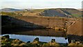
Birch Hill Reservoir
A reservoir built prior to 1907 (OS maps), viewed from East Hill. Visible is the steep set of stone steps up Birch Hill
Image: © Kevin Waterhouse
Taken: 29 Aug 2017
0.15 miles
5
Birch Hill Reservoir
East Hill is beyond. The reservoir is late Victorian or Edwardian
Image: © Kevin Waterhouse
Taken: 11 Dec 2013
0.17 miles
6
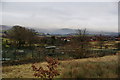
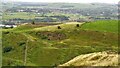
Allotments below Shore
The allotments include poultry. Beyond is the Stubley housing estate, and behind that the Rakewood Viaduct carrying the M62.
Image: © Bill Boaden
Taken: 31 Dec 2010
0.17 miles
7
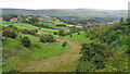
Middlewood Colliery Site
In the valley bottom between Pedler Brow and Starring Hill, only scant spoil heaps remain
Image: © Kevin Waterhouse
Taken: 6 Sep 2016
0.17 miles
8
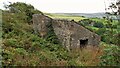
Stone Hut on East Hill
May have been used in connection with quarrying or mining. The site is marked as Filter Tank on OS maps from 1911 on. Inside the shed are several galvanised tanks but these may be connected with a former egg production site at the bottom of the hill
Image: © Kevin Waterhouse
Taken: 29 Aug 2017
0.18 miles
9
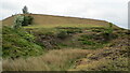
Old Quarry on Birch Hill
With the reservoir embankment on the skyline
Image: © Kevin Waterhouse
Taken: 11 Jun 2020
0.18 miles
