IMAGES TAKEN NEAR TO
Moss Side Street, ROCHDALE, OL12 8EP
Introduction
This page details the photographs taken nearby to Moss Side Street, OL12 8EP by members of the Geograph project.
The Geograph project started in 2005 with the aim of publishing, organising and preserving representative images for every square kilometre of Great Britain, Ireland and the Isle of Man.

There are currently over 7.5m images from over14,400 individuals and you can help contribute to the project by visiting https://www.geograph.org.uk
Image Map (Loading...)


Getting Data...Please wait
Leaflet Map data © OpenStreetMap
Images are licensed for reuse under creativecommons.org/licenses/by-sa/2.0
Notes
- Clicking on the map will re-center to the selected point.
- The higher the marker number, the further away the image location is from the centre of the postcode.
Image Listing (24 Images Found)
Images are licensed for reuse under creativecommons.org/licenses/by-sa/2.0
Image
Details
Distance
1
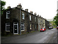
Shawforth: Moss Side Street
The houses are numbered consecutively 3 to 13.
Image: © Dr Neil Clifton
Taken: 7 Jun 2011
0.01 miles
2

Shawforth: Moss Side Street
There are only these three doors on this side of Moss Side Street: The middle door has a '1' on it, the other two have no numbers. Where No 2 is, is anybody's guess. Numbers 3 to 13, consecutive, are on the other side of the street.
Image: © Dr Neil Clifton
Taken: 7 Jun 2011
0.05 miles
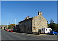
4
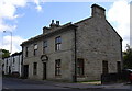
"The Red Lion" (Pub) Market Street, Shawforth, 1850
Now a house.
Image: © Robert Wade
Taken: 5 Aug 2007
0.06 miles
5
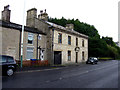
Shawforth: Former 'Red Lion'
This former pub is now just plain 232 Market Street, but its former name is perpetuated by the bus stop - 'Red Lion, Shawforth'.
Image: © Dr Neil Clifton
Taken: 7 Jun 2011
0.07 miles
7
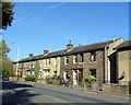
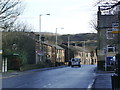
Terraced housing on Market Street, Shawforth
Image: © JThomas
Taken: 10 Oct 2018
0.08 miles
8
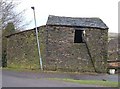
Derelict barn, Shawforth, Lancashire
Situated on a lane leading to the Landgate Quarry reclamation site only 200 metres from the A671. The street light and the detached drainpipe remain almost parallel!
Image: © michael ely
Taken: 20 Jan 2006
0.10 miles

10
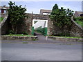
Shawforth Station Subway
Shawforth Station closed to passengers 1947.
Area now cleared and is covered by Knowsley Crescent. Subway opened out and used as access to the estate.
Image: © Peter Holton
Taken: 6 Jun 2004
0.13 miles