IMAGES TAKEN NEAR TO
Burnedge Close, ROCHDALE, OL12 8BU
Introduction
This page details the photographs taken nearby to Burnedge Close, OL12 8BU by members of the Geograph project.
The Geograph project started in 2005 with the aim of publishing, organising and preserving representative images for every square kilometre of Great Britain, Ireland and the Isle of Man.

There are currently over 7.5m images from over14,400 individuals and you can help contribute to the project by visiting https://www.geograph.org.uk
Image Map (Loading...)


Getting Data...Please wait
Leaflet Map data © OpenStreetMap
Images are licensed for reuse under creativecommons.org/licenses/by-sa/2.0
Notes
- Clicking on the map will re-center to the selected point.
- The higher the marker number, the further away the image location is from the centre of the postcode.
Image Listing (45 Images Found)
Images are licensed for reuse under creativecommons.org/licenses/by-sa/2.0
Image
Details
Distance

4
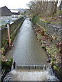
River Spodden
Looking north from Daniel Street, the brown tube on the left is a part of a flow meter
Image: © Alexander P Kapp
Taken: 4 Feb 2010
0.08 miles
5
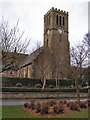
Church of St Mary and St Anselm
John Street, Whitworth.
Image: © David Dixon
Taken: 30 Mar 2010
0.08 miles
6
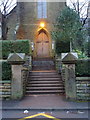
Our Immaculate Mother & St Anselm RC Church, Whitworth, Doorway
Image: © Alexander P Kapp
Taken: 4 Feb 2010
0.09 miles
7
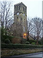
Our Immaculate Mother & St Anselm RC Church, Whitworth
Image: © Alexander P Kapp
Taken: 4 Feb 2010
0.09 miles
8
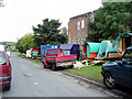
Gypsy encampment, Cowm Park Way, Whitworth
Image: © Dr Neil Clifton
Taken: 11 Sep 2005
0.09 miles