IMAGES TAKEN NEAR TO
Market Street, ROCHDALE, OL12 8BD
Introduction
This page details the photographs taken nearby to Market Street, OL12 8BD by members of the Geograph project.
The Geograph project started in 2005 with the aim of publishing, organising and preserving representative images for every square kilometre of Great Britain, Ireland and the Isle of Man.

There are currently over 7.5m images from over14,400 individuals and you can help contribute to the project by visiting https://www.geograph.org.uk
Image Map (Loading...)


Getting Data...Please wait
Leaflet Map data © OpenStreetMap
Images are licensed for reuse under creativecommons.org/licenses/by-sa/2.0
Notes
- Clicking on the map will re-center to the selected point.
- The higher the marker number, the further away the image location is from the centre of the postcode.
Image Listing (20 Images Found)
Images are licensed for reuse under creativecommons.org/licenses/by-sa/2.0
Image
Details
Distance
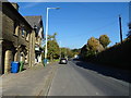
3
Market Street Whitworth
This is the boundary between Shawforth and Whitworth on the A671, the main road between Rochdale and Bacup.
Image: © michael ely
Taken: 30 Dec 2007
0.13 miles
4
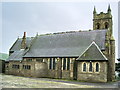
The Parish Church of St John the Evangelist, Facit
Image: © Alexander P Kapp
Taken: 21 Jun 2007
0.14 miles
5
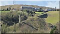
Facit Chimney & Quarry Tramway Incline
View to Cowm Top from across the valley at Whitworth Cemetery
Image: © Kevin Waterhouse
Taken: 6 Apr 2021
0.15 miles
6
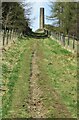
Facit Chimney adjacent to Quarry Tramway Incline
View up the Tramway Incline
Image: © Kevin Waterhouse
Taken: 6 Apr 2021
0.15 miles
7

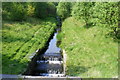
Facit Chimney adjacent to Quarry Tramway Incline
View down the Quarry Tramway Incline from near Cowm Top. Facit in the valley below
Image: © Kevin Waterhouse
Taken: 6 Apr 2021
0.15 miles
9
Old Milestone by the A671, Market Street, Whitworth
Carved stone post by the A671, in parish of Whitworth (Rossendale District), by Facit Church, against wall, immediately behind A671, on East side of road. Erected by the Rochdale & Burnley turnpike trust in the 19th century. Defaced. Possible earlier milestone behind.
Inscription reads:-
: To (Rochdale) / 4 : : To (Bacup) / 3 :
Milestone Society National ID: LA_BCRD03
Image: © J Higgins
Taken: 1 Nov 2008
0.16 miles
10
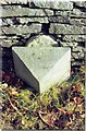
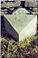
Old Milestone by the A671, Market Street, Facit
Carved stone post by the A671, in parish of WHITWORTH (ROSSENDALE District), by Facit Church, against wall, on East side of road. Lancs CC stone triangle, erected by the County Council in the 19th/20th century.
Inscription reads:-
: TO (ROCHDALE) / 4 MILES : : TO (BACUP) / 3 MILES :
Milestone Society National ID: LA_BCRD03A.
Image: © J Higgins
Taken: 1 Nov 2008
0.16 miles