IMAGES TAKEN NEAR TO
Faraday Rise, ROCHDALE, OL12 7NP
Introduction
This page details the photographs taken nearby to Faraday Rise, OL12 7NP by members of the Geograph project.
The Geograph project started in 2005 with the aim of publishing, organising and preserving representative images for every square kilometre of Great Britain, Ireland and the Isle of Man.

There are currently over 7.5m images from over14,400 individuals and you can help contribute to the project by visiting https://www.geograph.org.uk
Image Map (Loading...)


Getting Data...Please wait
Leaflet Map data © OpenStreetMap
Images are licensed for reuse under creativecommons.org/licenses/by-sa/2.0
Notes
- Clicking on the map will re-center to the selected point.
- The higher the marker number, the further away the image location is from the centre of the postcode.
Image Listing (18 Images Found)
Images are licensed for reuse under creativecommons.org/licenses/by-sa/2.0
Image
Details
Distance
1
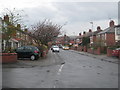
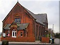
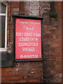
Phyllis Street Rochdale
With distant views of the moors.
Image: © Rod Allday
Taken: 10 Apr 2009
0.08 miles
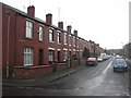
3
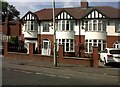
Whalley Road, Rochdale
Illuminated by setting sun in the west.
Image: © Bill Boaden
Taken: 13 Apr 2010
0.13 miles
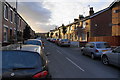
4
Edenfield Road
Looking east towards Rochdale
Image: © Alexander P Kapp
Taken: 13 Feb 2009
0.16 miles

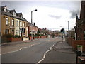
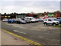
9
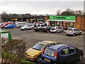
Cutgate Shopping Precinct
Taken from the pedestrian access at the northern end of the precinct.
Image: © David Dixon
Taken: 20 Jan 2010
0.20 miles
10
Cutcate Shopping Precinct
Taken from the vehicular access toand from Edenfield Road.
Image: © David Dixon
Taken: 20 Jan 2010
0.20 miles