IMAGES TAKEN NEAR TO
Ings Lane, ROCHDALE, OL12 7LQ
Introduction
This page details the photographs taken nearby to Ings Lane, OL12 7LQ by members of the Geograph project.
The Geograph project started in 2005 with the aim of publishing, organising and preserving representative images for every square kilometre of Great Britain, Ireland and the Isle of Man.

There are currently over 7.5m images from over14,400 individuals and you can help contribute to the project by visiting https://www.geograph.org.uk
Image Map (Loading...)


Getting Data...Please wait
Leaflet Map data © OpenStreetMap
Images are licensed for reuse under creativecommons.org/licenses/by-sa/2.0
Notes
- Clicking on the map will re-center to the selected point.
- The higher the marker number, the further away the image location is from the centre of the postcode.
Image Listing (7 Images Found)
Images are licensed for reuse under creativecommons.org/licenses/by-sa/2.0
Image
Details
Distance
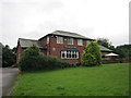
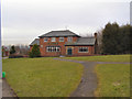
1
Former Local Authority houses, Ings Avenue, Rochdale, Lancashire
These semi-detached homes, built for Rochdale Corporation soon after World War II, are now privately owned.
Image: © Dr Neil Clifton
Taken: 30 Sep 2005
0.02 miles

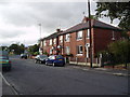
3
Rooley Moor Road, Spotland Fold
Looking north.
Image: © David Dixon
Taken: 3 Mar 2010
0.22 miles
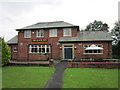
4
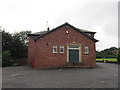
The Black Dog on Ings Lane
A Sam Smith's public house.
Image: © Ian S
Taken: 10 Jul 2012
0.24 miles
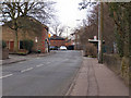
5
The Black Dog
Between Redfearn Wood and Rooley Moor Road, Caldershaw.
Image: © David Dixon
Taken: 3 Mar 2010
0.24 miles
6
The Black Dog on Ings Lane
A Sam Smith's public house.
Image: © Ian S
Taken: 10 Jul 2012
0.24 miles