IMAGES TAKEN NEAR TO
Harridge Avenue, ROCHDALE, OL12 7HN
Introduction
This page details the photographs taken nearby to Harridge Avenue, OL12 7HN by members of the Geograph project.
The Geograph project started in 2005 with the aim of publishing, organising and preserving representative images for every square kilometre of Great Britain, Ireland and the Isle of Man.

There are currently over 7.5m images from over14,400 individuals and you can help contribute to the project by visiting https://www.geograph.org.uk
Image Map (Loading...)


Getting Data...Please wait
Leaflet Map data © OpenStreetMap
Images are licensed for reuse under creativecommons.org/licenses/by-sa/2.0
Notes
- Clicking on the map will re-center to the selected point.
- The higher the marker number, the further away the image location is from the centre of the postcode.
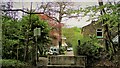
Image Listing (15 Images Found)
Images are licensed for reuse under creativecommons.org/licenses/by-sa/2.0
Image
Details
Distance
1
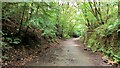
Former Rochdale to Bacup Railway Trackbed after Shawclough
Adverse Gradient after heading North from the former Shawclough Station at Dell Road bridge
Image: © Kevin Waterhouse
Taken: 30 Jul 2020
0.05 miles
2
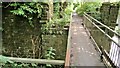
Footbridge replacement for Railway Bridge at Shawclough
View towards Rochdale over former Shawclough Station access road
Image: © Kevin Waterhouse
Taken: 30 Jul 2020
0.06 miles
3
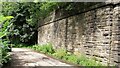
Retaining Wall for Railway on Dell Road Shawclough
Retaining Wall for Rochdale to Bacup Railway, view North
Image: © Kevin Waterhouse
Taken: 30 Jul 2020
0.06 miles
4
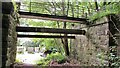
Railway Bridge Abutments at Shawclough Station Access Road
Footbridge has replaced original Railway Bridge. Concrete Block barriers stop vehicle entry to Woodland Road from Dell Road
Image: © Kevin Waterhouse
Taken: 30 Jul 2020
0.06 miles
6

Former Rochdale to Bacup Railway Trackbed at Shawclough
Start of trail on trackbed with Dell Road retaining wall to the left
Image: © Kevin Waterhouse
Taken: 30 Jul 2020
0.08 miles
7
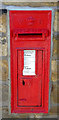
Victorian postbox on Shawclough Road, Rochdale
Postbox No. OL12 67.
Image: © JThomas
Taken: 10 Oct 2018
0.08 miles
9
Shawclough and Healey Railway Station (Site of)
Looking towards Rochdale on the dismantled line from Bacup. A housing estate now stands on the route ahead.
Image: © Paul Hogg
Taken: 24 May 2008
0.15 miles
10
Modern & WWII Pole Barriers
Modern concrete block across Dell Road and WWII pole barrier still surviving from when the mill beyond was a munitions filling factory.
Image: © Kevin Waterhouse
Taken: 17 May 2021
0.18 miles