IMAGES TAKEN NEAR TO
Shawclough Way, ROCHDALE, OL12 7HF
Introduction
This page details the photographs taken nearby to Shawclough Way, OL12 7HF by members of the Geograph project.
The Geograph project started in 2005 with the aim of publishing, organising and preserving representative images for every square kilometre of Great Britain, Ireland and the Isle of Man.

There are currently over 7.5m images from over14,400 individuals and you can help contribute to the project by visiting https://www.geograph.org.uk
Image Map
Images are licensed for reuse under creativecommons.org/licenses/by-sa/2.0
Notes
- Clicking on the map will re-center to the selected point.
- The higher the marker number, the further away the image location is from the centre of the postcode.
Image Listing (16 Images Found)
Images are licensed for reuse under creativecommons.org/licenses/by-sa/2.0
Image
Details
Distance
1
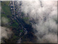
Whitworth Road from the air
The A671 is named Market Street in the lower half of the photo, becoming Whitworth Road as it heads towards the centre of Rochdale.
Image: © Thomas Nugent
Taken: 19 Oct 2018
0.13 miles
2
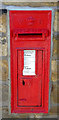
Victorian postbox on Shawclough Road, Rochdale
Postbox No. OL12 67.
Image: © JThomas
Taken: 10 Oct 2018
0.16 miles
4
Shawclough and Healey Railway Station (Site of)
Looking towards Rochdale on the dismantled line from Bacup. A housing estate now stands on the route ahead.
Image: © Paul Hogg
Taken: 24 May 2008
0.17 miles
6
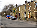
The Healey
Public house at the end of a row of terraced houses on Shawclough Road.
Image: © David Dixon
Taken: 3 Mar 2010
0.20 miles
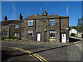
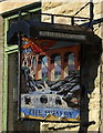
7
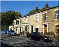
The Healey public house
On Shawclough Road (B6377).
Image: © JThomas
Taken: 10 Oct 2018
0.20 miles
9
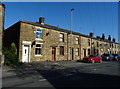
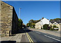
Terraced housing on Shawclough Road (B6377)
Image: © JThomas
Taken: 10 Oct 2018
0.21 miles
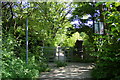
10

Former Rochdale to Bacup Railway Trackbed at Shawclough
Start of trail on trackbed with Dell Road retaining wall to the left
Image: © Kevin Waterhouse
Taken: 30 Jul 2020
0.22 miles