IMAGES TAKEN NEAR TO
Roefield Terrace, ROCHDALE, OL12 7BJ
Introduction
This page details the photographs taken nearby to Roefield Terrace, OL12 7BJ by members of the Geograph project.
The Geograph project started in 2005 with the aim of publishing, organising and preserving representative images for every square kilometre of Great Britain, Ireland and the Isle of Man.

There are currently over 7.5m images from over14,400 individuals and you can help contribute to the project by visiting https://www.geograph.org.uk
Image Map (Loading...)


Getting Data...Please wait
Leaflet Map data © OpenStreetMap
Images are licensed for reuse under creativecommons.org/licenses/by-sa/2.0
Notes
- Clicking on the map will re-center to the selected point.
- The higher the marker number, the further away the image location is from the centre of the postcode.
Image Listing (43 Images Found)
Images are licensed for reuse under creativecommons.org/licenses/by-sa/2.0
Image
Details
Distance
1
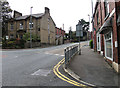
Rooley Moor Road, Rochdale end
Rooley Moor Road starts as a suburban road at Spotland Bridge before becoming a moorland track over the tops leading to Stacksteads in the Rossendale Valley.
Image: © michael ely
Taken: 19 Aug 2011
0.07 miles
2
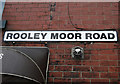
Rooley Moor Road at Spotland Bridge
A street sign that sets off-road cyclists' pulses racing. This is the start of the moorland track (a suburban road at first) that heads over the tops to Stacksteads in the Rossendale Valley. For most of its length it forms part of the Pennine Bridleway.
Image: © michael ely
Taken: 19 Aug 2011
0.07 miles


5
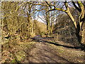
Spodden Valley
"Green corridor" along the side of the River Spodden. See http://www.rochdaleonline.co.uk/news-features/21/spodden-valley/1563/lower-spodden-valley-green-corridor-proposal for information about the Spodden Valley green corridor project.
Image: © David Dixon
Taken: 1 Mar 2010
0.10 miles
6
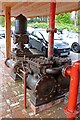
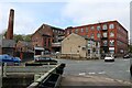
Spotland Bridge New Mill, Spotland Bridge - steam fire pump
Cotton spinning mill, now industrial centre. c1833 with early 20th century extension. Built for the firm of Joseph Butterworth and Co. Ltd. Listed Grade II.
In the car park under an open sided cover is this relocated and preserved steam fire pump. It is a horizontal duplex non-rotative pump by Mather & Platt of Manchester. It was apparently originally in the basement of the mill.
Image: © Chris Allen
Taken: 23 Apr 2024
0.11 miles
7
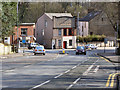
Spotland Bridge
Looking downhill on Spotland Road towards the junction at Spotland Bridge.
Image: © David Dixon
Taken: 1 Mar 2010
0.11 miles
8
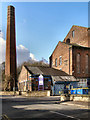
Spotland Bridge New Mill, Spotland Bridge
Cotton spinning mill, now industrial centre. c1833 with early 20th century extension (hidden by the older mill). Built for the firm of Joseph Butterworth and Co. Ltd. The twin beam engine house can be identified by its two tall windows with semi-circular tops. The octagonal brick stack has probably been shortened.
Listed Grade II.
Image: © Chris Allen
Taken: 23 Apr 2024
0.11 miles
10
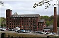
Spotland Bridge New Mill, Spotland Bridge
Cotton spinning mill, now industrial centre. c1833 with early 20th century extension (hidden by the older mill). Built for the firm of Joseph Butterworth and Co. Ltd. On the right hand end is the twin beam engine house. The octagonal brick stack has probably been shortened.
Listed Grade II.
Image: © Chris Allen
Taken: 23 Apr 2024
0.11 miles